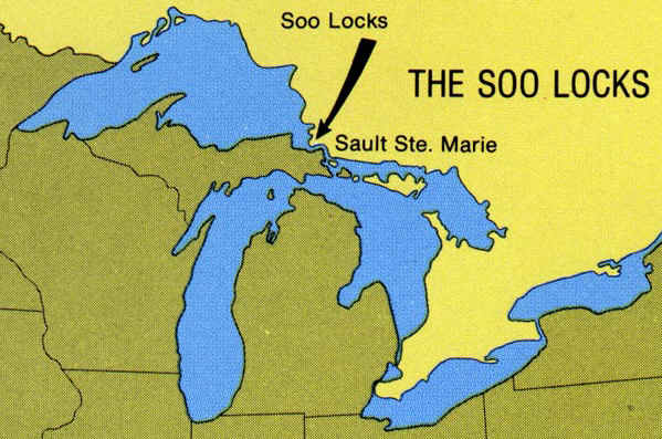
THE SOO LOCKS
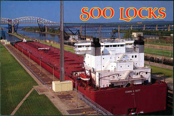
Postcard
All of the boat
traffic that flows into or out of Lake Superior must move through the
locks of the St. Mary's River, at Sault Ste. Marie. The St. Marys River is
the only water connection between Lake Superior and the other Great Lakes.
There is a section of the river known as the St. Marys Rapids where the
water falls about 21 feet from the level of Lake Superior to the level of
the lower lakes. This natural barrier to navigation made necessary the
construction of the locks project known as the St. Marys Falls
Canal.
The world-famous
Soo Locks form a passage for deep-draft ships around the Rapids ("Sault")
in the St. Marys River. The "Soo Locks" have the distinction of
being the busiest locks in the world.
Here are some facts about the
locks:
Water not flowing through the locks or down
the St. Mary's River nearby is diverted into a canal, and the drop in head
is used to generate hydroelectric power. The U.S. Hydroelectric
Power Plant located north of the locks generates over 150 million kilowatt
hours of electrical power each year. The first priority for the use of the
power is for operating machinery at the Soo Locks. The surplus is
purchased by a private power company and is distributed to homes and
businesses in Sault Ste. Marie and surrounding
communities.
The entire facility at the St. Marys
Falls Canal is operated and maintained by the Corps of Engineers, US Army
Engineer District, Detroit.
The Poe Lock has the
largest capacity of the four locks. The lock, completed in 1968, took six
years to build and is the only lock ever constructed between two operating
locks.
Inspection of the locks themselves, the
culverts, and galleries is done periodically to check the structural
soundness of these areas. This inspection is normally done during the
winter months.
Many different types of vessels pass
through the locks during a year, varying in size from the small passenger
vessels and work boats to large ships carrying more than 72,000 tons of
freight in a single cargo. In recent years, the number of passages through
the locks has averaged about 12,000 per year, down from previous years due
to the larger vessels being able to carry more
freight.
The channels through the St. Marys River
have been deepened to permit ship loading to a maximum draft of 25.5 feet
at low water. When lake levels are above the low water datum, the larger
ships load to take advantage of the deeper water at a rate of over 200
tons per inch of additional loading.
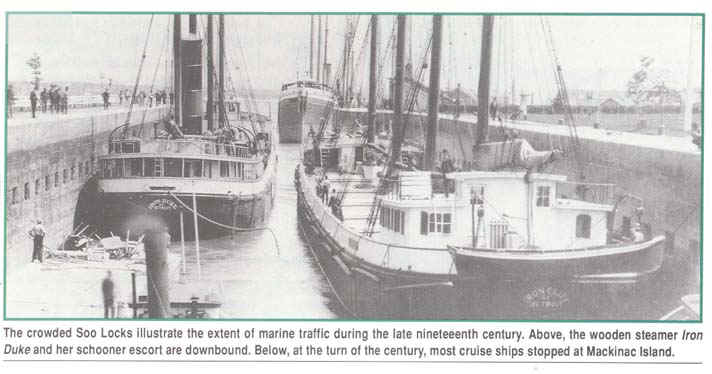
Postcard
How do the locks (and indeed, all locks) work? View this
animation to see. It's really quite simple--just a matter of
closing and opening some gates. No pumps are involved.
After the ship is in the lock, water is allowed to
flow in and raise the ship up (if it is travelling to the higher
lake--Superior) or water is allowed to flow out and lower the ship (if it
is traveling to the lower lake--Huron). Then the doors are simply
opened (see below) and the ship moves on its way. Traveling through
the US side of the locks is free to all ships.
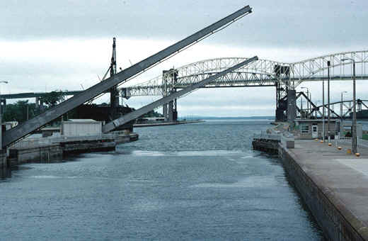
A TRIP
THROUGH A LOCK:
Ships travelling from Lake Huron to Lake Superior must
enter the locks as shown below. Note that the water level is low in
the lock (you can tell this because the walls of the lock are exposed, not
filled to the brim with water). The lock doors are open, and the
ship sails in. You are looking north.
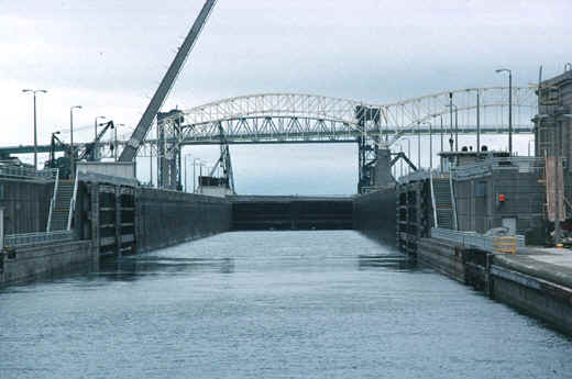
Source: Photograph by Randy Schaetzl, Professor of Geography - Michigan State University
Now, once in the lock, the doors
close and water begins to pour into the lock. Turn around on the
ship and see--the image below (looking south) shows the lock doors closing
so the ship can be raised up to the level of Lake Superior. Note
again how much of the doors is exposed--a clue that the water is low in
the lock and that it is at the level of the lower lake--Huron.
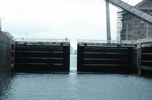
Source: Photograph by Randy Schaetzl, Professor of Geography - Michigan State University
Once the water level in the lock has been raised to that of Lake
Superior, the doors are opened and the ship sails out, into the higher
lake. The image below is what such a ship would see in that
situation. The view is to the north, into Lake Superior.
Source: Photograph by Randy Schaetzl, Professor of Geography - Michigan State University
In the aerial view below, one can see the four sets of locks, and a
freighter moving through, into Lake Superior. Note that, in two of
the locks, the water level is lowered, allowing boats from Michigan-Huron
to enter.
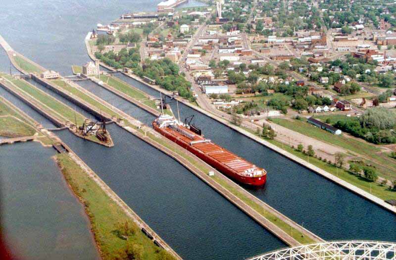
Source: Unknown
History of the Locks
Before white men came to the area, the Ojibway Indians who lived nearby
portaged their canoes around the rapids to reach Lake Superior from the
St. Marys River. The image below is from 1850.
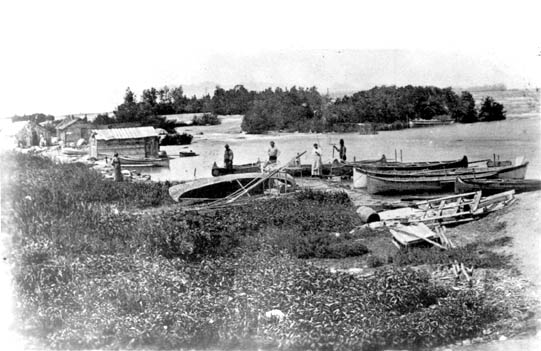
Source: Unknown
The falls
(or rapids) of the St. Mary's River were a common "stopping point" for
Indians. The falls often served as a trading point, or perhaps a place to
meet and exchange stories. It also was a great fishing spot
(especially for Whitefish) for the Native Americans (and still is...see
the image below).
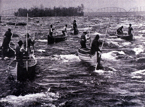
Source: Unknown
The
spring catch of Whitefish was crucial to their health and livelihood, as
at the end of winter their food supplies were scarce, and their need for
quality protein was high.
Early pioneers arriving in the territory were
also forced to carry their canoes around the rapids. When settlement of
the northwest Territory brought increased trade and large boats, it became
necessary to unload the boats, haul the cargoes around the rapids in
wagons, and reload in other boats.
In 1797, the
Northwest Fur Company constructed a navigation lock 38 feet long on the
Canadian side of the river for small boats. This lock remained in use
until destroyed in the War of 1812. Freight and boats again needed to be
portaged around the rapids.
Congress passed an act
in 1852 granting 750,000 acres of public land to the State of Michigan as
compensation to the company that would build a lock permitting waterborne
commerce between Lake Superior and the other Great Lakes. The Fairbanks
Scale Company, which had extensive mining interests in the upper
peninsula, undertook this challenging construction project in
1853.
Building the locks in the 1850's was a major
engineering project, since large amounts of solid rock had to be
moved. The images below show part of the construction of the locks,
and an early view of the locks.
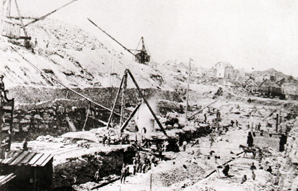
Source: Unknown
In spite of adverse conditions, Fairbanks
completed a system of two locks, in tandem, each 350 feet long, within the
2 year deadline set by the State of Michigan. On May 31, 1855, the locks
were turned over to the state and designated as the State Lock. The
canal had opened on schedule in June 1855, but its cost ran three times
the estimate, at just under $1,000,000.
An important date: JUNE 22, 1855. The passage of
the steamer Illinois through the locks at Sault Ste. Marie marks the
opening of unobstructed shipping between Lakes Superior and Huron. Ships
are no longer forced to stop at Sault Ste. Marie and portage their cargoes
around the rapids of the St. Mary's River, which drops twelve feet from
Lake Superior to Lake Huron. The canal is the result of a long-sought 1852
grant by Congress to Michigan of 750,000 acres of public land.
Construction, begun in mid-1853, has progressed despite cost overruns,
food shortages, a hostile climate and a cholera epidemic. The mile-long
canal and two 350-foot locks arranged in tandem have been completed in two
years. The Sault locks provide new impetus to Michigan's fledgling
mining
industry. Copper
mining on the Keweenaw Peninsula began in the early 1840s, and
Michigan led the nation in copper production for many years. In 1844
surveyor William A.
Burt discovered iron ore deposits near Negaunee.
Iron ore mining
expanded gradually, but by the late nineteenth century Michigan produced
more iron ore than any other state. Michigan also produced significant
amounts of salt, gypsum, oil and natural
gas.
Boats
which passed through the State Lock (picture below) were required to pay a
toll of four cents per ton, until 1877, when the toll was reduced to three
cents. Within a few years, commerce through the canal had grown to
national importance, and the need for new locks became clear. The funds
required exceeded the state’s capabilities, and thus, in 1881 the locks
were transferred to the United States government under the jurisdiction of
the US Army Corps of Engineers. The Corps has operated the locks, toll
free, since that time.
The opening of the canal, named the
Michigan State Locks, but eventually called simply the Soo Locks,
perfectly coincided with the increased demand for iron as railroads
expanded westward. Between 1850 and 1860, the railroad network in the
United States nearly quadrupled in size. The new locks expedited the
shipment of much-needed iron ore to steel mills in the southern Great
Lakes. In return, investment capital flowed north to the Lake Superior
region, expanding mining operations and improving transportation
arteries.
Source: Unknown
The first load of iron ore through
the Soo Locks amounted to 132 tons in August 1855. Total ore tonnage that
year was 1,447. During the 1860 shipping season 120,000 tons of ore passed
through the Soo Locks. One century later the total volume of downbound
iron recorded at the Soo exceeded 100 million tons.
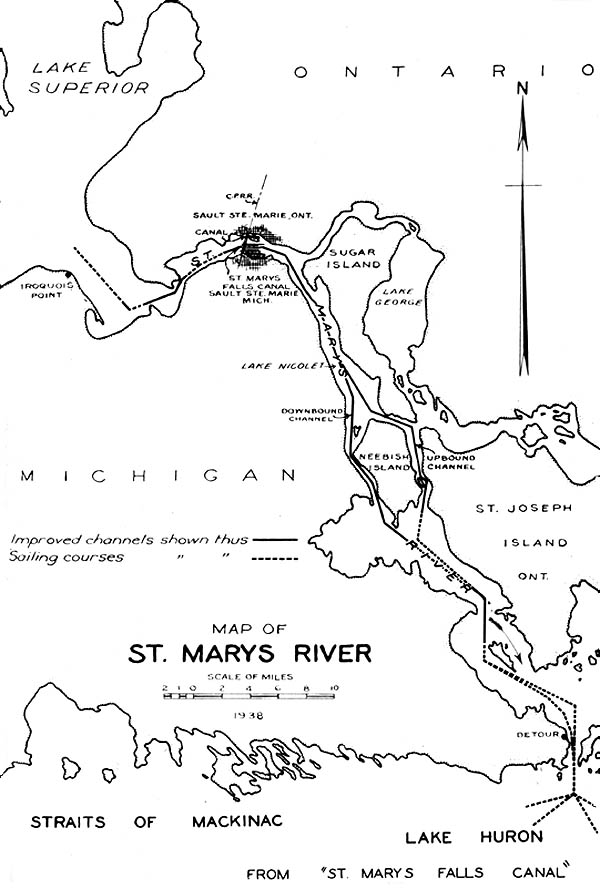
The falls of the St. Mary's River, where today exist the Soo Locks seen above, are present because of a resistant sill (layer) of rock within the river channel. The map below shows that area of the river and its main islands in 1938.
Source: Unknown
The Soo Locks during World War II
During World War II, the fear of axis attacks on the Soo Locks was extremely prevalent throughout the United States. Although far from the European and Pacific theater, the Soo Locks played an important role during World War II, due to the large amounts of iron ore being transported on large barges through the locks. 90% of America’s iron ore during this time was shipped through the Soo Locks to be transported to steel mills and then factories to build war machinery, such as tanks, planes, and munition.
The fear of a homeland attack in America grew as the war waged on, and with the growing importance of the Soo Locks and iron for the war effort, military protection of the Soo Locks was critical. By 1942, large numbers of troops were sent to Sault Sainte Marie to protect the Soo Locks, making it one of the most guarded places in the United States during World War II. The militarization of the Soo Locks was so large that Fort Brady-a military fort built in Sault Sainte Marie to guard against British invasion from Canada- was so full, there was no room to house all the military personnel.
The military defense tactics were very extensive. Defenses included land, air, and sea to protect the Soo Locks from foreign attacks. Air defenses including searchlights to patrol the sky were added, and defenses against possible torpedo attacks were put in place.
During 1942 an order for construction of a new lock was put into place. This lock would allow larger barges to transport larger amounts of iron ore through the Soo Locks. The new MacArthur lock was completed soon after orders in 1943, allowing larger freighters to pass through. The name of the new lock which replaced the previous Weitzel Lock was named after Douglas MacArthur, a five-star general in the Pacific theatre of World War II.
Due to the lessening threat to the Soo Locks by Axis powers during the war, military security was lessened in 1943. The Soo Locks were never attacked during World War II despite the fear of foreign threat.
Today, the Soo Locks are still responsible for 90% of America’s iron ore transportation. The Soo Locks are still known as a military target, but security for the Soo Locks has decreased significantly since World War II.
This material has been compiled for educational use only, and may not be reproduced without permission. One copy may be printed for personal use. Please contact Randall Schaetzl (soils@msu.edu) for more information or permissions.