The settlement of Michigan and the Northwest Territories, and
the many conflicting claims on this land, are reviewed in the series of
maps that follow.
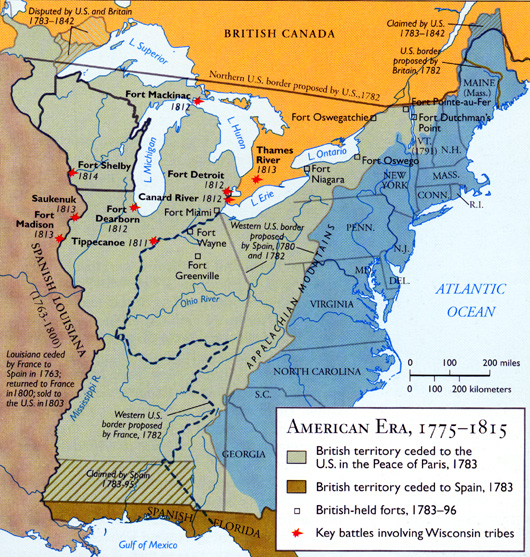
Americans were slow to move into Michigan, even after
the lands had come under American control. The British continued the
fur trade on US lands, encouraged Native nations to resist US expansion,
and repossessed some western forts. These acts contributed to the War
of 1812, and the formation of a resistance movement by the Shawnee leader
Tecumseh. Only with the end of the war (in 1815) did the US secure its claim
to the area.
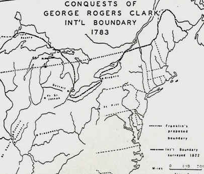
For more than seven decades after the American Revolution,
what is now Michigan was part of various US territories. Citizens living
in territories did not have all the rights that citizens living in states
did. Territories did serve an important function, however, in setting
the stage for eventual statehood.
Isle Royale.
The Treaty of 1783 specifically gave Isle Royale to the United States.
It stated that the water boundary should run "northward of the isles
Royal and Phelipeaux." The latter island first appeared on a map prepared
by the cartographer Bellin in 1744. The island does not exist, but it
continued to appear on maps of Lake Superior for many years, including
the map used in the Paris peace talks, in 1783. Many writers and others,
including park rangers at Isle Royale National Park, have perpetuated
the story that Benjamin Franklin, knowing of the existence of copper
deposits on Isle Royale, managed to include the island within the United
States because of that knowledge. This story, for the most part, has
now been disproved. Mitchell’s map shows both Isle Royale and the mythical
island of Phelipeaux centrally located in Lake Superior, which was, in the
case of Isle Royale, considerably to the south of where that island is
actually located. According to historians, the natural water "dividing
line" that the negotiators were attempting to describe in the Treaty
of 1783 would run north of Isle Royale, which is no doubt the reason
the island was placed on the American side of the line (see the map below),
where it would ultimately fall within the boundaries of the state of Michigan.
Source: Atlas of Wisconsin
Prior to and during the War of 1812, parts of Michigan again became
British territory. After losing this war, the British again spent
some time with the US Government crafting the Canada-US (or more precisely,
Quebec-Michigan) boundary. The exact location of the international
boundary, which had been determined by the Paris Peace Treaty of 1783,
had not been determined at that time, although two proposals were most
favored: One proposal, shown below, would have continued the 45th
parallel west, from Vermont. Of course, this proposal had the distinct
disadvantage of allowing neither the US nor Canada a water passage through
the Great lakes without crossing each other's border several times.
The other proposal (the one that was accepted) is the one we use today,
which essentially "splits" four of the five the Great Lakes with Canada.
Only Lake Michigan lies wholly within the US.
Source: Unknown
Mackinac Island, which had been held by the Brits
during the war, was turned over to the US and became part of Michigan.
The British, again engaged in boundary issues with the "yankees", assumed
that Drummond Island (south of the Soo, NE of Mackinac Island, near the
entrance to the St. Mary's River) lay on their side of the line.
Having decided not to divide up any disputed islands, an international
boundary commission eventually gave Drummond Island to the US, since it
laid to the west of the channel normally used to navigate between Lakes
Huron and Superior. In exchange, Canada was given Bois Blanc Island,
at the mouth of the Detroit River. Sugar Island, to the NE of Drummond,
stayed in dispute until a treaty in 1842 gave it to the Canadians.
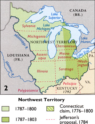
After the Great Lakes region had been ceded to the
United States by Great Britain, it was immediately "claimed" by several
eastern states. The map below shows the extent of this "land grab".
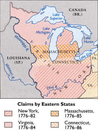
Source: Atlas of Michigan, ed.
Lawrence M. Sommers, 1977.
In 1787, Congress put an end to these conflicting claims, essentially
saying that no existing state could lay claim to the Great Lakes region.
Instead, it issued the Northwest Ordinance, establishing the Northwest
Territory (see map below).
Source: Unknown
This Ordinance established the "Old Northwest" from land that had been
ceded to the fledgling United States from Britain, after the Revolutionary
War. Nonetheless, parts of the Northwest Territory (see map below,
the green area) were still claimed by some eastern states. The
map below also outlines Thomas Jefferson's proposal for subdividing the
NW Territory into states. Can you image the city of East Lansing,
Metropotamia???!! Fortunately, Jefferson was overruled, and the
US government eventually decided to divide the NW Territory into no more
than five states.
Source: Atlas of Michigan, ed.
Lawrence M. Sommers, 1977.
Problems of conflicting land claims (under the old
"metes and bounds" system) were so serious in the seaboard colonies,
and were becoming so threatening west of the Appalachians, that the founding
fathers determined they must be solved before settlement could be allowed
"on the western waters." Their largest block of unclaimed land
was the Northwest Territory, the area north of the Ohio River, east of
the Mississippi, and south of the Great Lakes. This "Old Northwest" became
the nucleus of the original public domain of the United States when the
Commonwealth of Virginia ceded it to Congress in 1784.
Congress therefore appointed a committee, under the
chairmanship of Thomas Jefferson, to prepare an overall plan for the
systematic survey and subdivision of the public domain before it was
alienated to intending settlers. The public domain consists of all land
directly owned by the government, alienation is the process by which
the government transfers the ownership of public land to private citizens.
It is always understood that the government reserves the right of eminent
domain, the right to take back private property if it is needed for public
use.
Jefferson’s proposal, as modified and adopted by
congress in the Land Ordinance of 1785, is known as
the Congressional Public Land Surveys system, the US Public Land
Survey (USPLS) System, or the Township and Range Survey System;
these names are used interchangeably. The fundamental features of the system are: (1) the land had to be surveyed
before it could be alienated and settled, (2) the survey lines were oriented
in cardinal compass directions (N, S, E, or W) and, (3) the land was
divided into townships six miles square, which were subdivided into sections
of one square mile each, or 640 acres.
The young American nation used the state of Ohio
as a laboratory for experimenting with different kinds of rectangular
survey systems. In 1785 Chief Geographer Thomas Hutchins ran the first
survey line from Pennsylvania 42 miles west into Ohio before his party
encountered a group of unfriendly Indians who offered them free haircuts.
They decided to beat a hasty retreat to Pittsburgh.
Unfriendly Indians were merely one of the routine
hazards of survey parties. They had to hack their way through thick forests
to run their lines across rugged country, and were regularly subject
to attack by wild animals, snakes, mosquitoes, and malaria (ague), on
top of all the usual vicissitudes of wind and weather to which anyone
is exposed who works outdoors. And they had little time for pinpoint accuracy
or niceties of detail, because settlers clamoring for land were hot on
their heels.
The American era did not begin auspiciously. Although
the Land Ordinance of 1787 provided for the government of the old Northwest
Territory, of which Michigan was a part, that government seemed remote
and indifferent. British influence kept the Indians uneasy and sullen,
and there were few American settlers in the region. By the Treaty of
Greenville in 1795, the Indians ceded a tract six miles wide extending from
Lake St. Clair to the River Raisin, as well as Mackinac Island, Bois
Blanc Island, and other important lands. This was the first of
the cessions of land by the Indians,
to the US government. In so doing, these land cessions opened the
way for pioneers to finally, safely, settle the land.
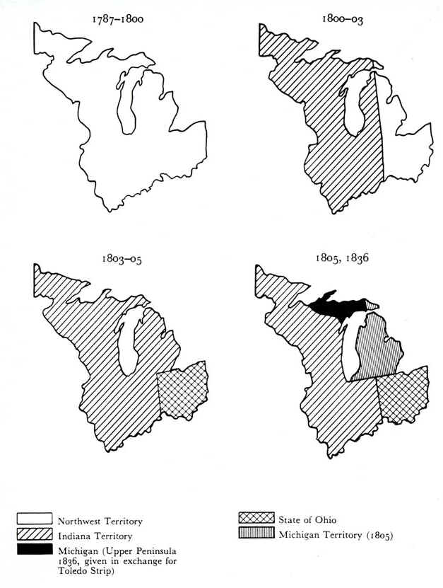
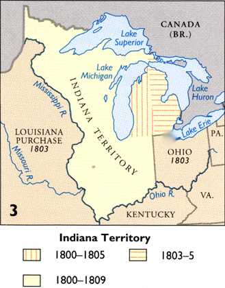
In 1796 Wayne County was organized as part of the old Northwest Territory
and included most of present-day Michigan, with large parts of present-day
Ohio, Indiana, Illinois, and Wisconsin. In 1800 the Territory was divided
by a line running from the Ohio River up through the center of the Lower
Peninsula (see map below), all west of that line being included in the
new Territory of Indiana, all east of it in the reduced Northwest Territory.
But in 1803, when Ohio was admitted as a State, all of the present State
of Michigan was included in the Territory of Indiana.
The people of Michigan were dismayed to discover
that their capital was to be at Vincennes, hundreds of miles distant
across the wilderness. Within a few years the people’s patience was beginning
to run out. They were terribly irritated when the first election was
held in Indiana Territory in 1804 and the proclamation did not arrive
in Detroit until after the event!
Congress at length yielded, and on January 11, 1805,
President Jefferson approved an act creating "Michigan Territory". It
included all the southern peninsula and the northern one eastward from
Mackinac. The southern line ran eastward from the tip of Lake Michigan
and included the Toledo Strip in Ohio.
By 1818, when the Indians were expelled, the bugs
had been worked out of the system in other parts of the state, and the
rectangular survey system that was used in northwestern Ohio (Ohio Territory,
see the map below) became the standard that was subsequently extended
to most of the United States west of the Appalachians. In many places
the straight north-south and east-west lines of the survey are now state, county, and minor civil
boundaries as well. The lines of the survey system determine the
boundaries of most properties, and all but the most important highways
follow property boundaries instead of cutting across them. The rural
Midwest is crisscrossed by straight "section-line" roads spaced at
one-mile intervals that intersect at right angles, and the survey is why
many American farmers reckon their land in terms of sections of 640
acres, quarters of 160 acres, and "forties," or quarters of quarters.
Eventually, in 1803, Ohio became a state (see map below) and Michigan
was a part of "Indiana Territory."
Source: Atlas of Michigan, ed.
Lawrence M. Sommers, 1977.
Michigan protested being a part of Indiana Territory, because its territorial
capital was Vincennes, Indiana (the "x" on the map). That was simply
too far from where most Michiganians lived. So, shortly thereafter,
in 1805, Michigan Territory was carved out of Indiana Territory, as the
map below shows.
Source: Atlas of
Michigan, ed. Lawrence M. Sommers, 1977.
Source: Atlas of Michigan, ed. Lawrence M. Sommers, 1977.
This material has been compiled for educational use only, and may not be reproduced without permission. One copy may be printed for personal use. Please contact Randall Schaetzl (soils@msu.edu) for more information or permissions.