INDIAN LAND CESSIONS
The status of the Indian tribes under American law was that
of nations within a nation. Each of the treaties with Indian tribes was subject
to the approval of the United States Senate, just as were treaties with foreign
countries.
What is now Michigan was included within the territories
ceded to the United States by Great Britain in 1783. But the land
of Michigan was the property of the Indian tribes and was legally recognized
as such. It remained the property of those tribes until it was ceded to the
United States by treaty.
The tradition of peace among the Indian tribes of the
Great Lakes region was rudely shattered with the penetration of the French
and English into the West. Even before the period of actual white settlement,
tribal boundaries had shifted as a result of pressure from the Iroquois on
the east and the Sioux on the west. The Sauk, reduced in numbers, combined
with the Fox and withdrew to Illinois; the Mascoutin and Miami were banished
from the region. The Wyandot (or Huron), an Iroquoian tribe east of Lake
Huron, were swept from their holdings by other tribes of Iroquois, united
in the famous Five Nations. They fled to various parts of the north in 1649
and, in 1680, settled around Detroit.
Before settlers could legally obtain any land,
the government first had to persuade the Indian tribes to relinquish their
claims to the land. To the American pioneer, the Indian had no positive effect
on the economy. As the fur trade declined and agriculture took its place
as the mainstay of Michigan’s economy, the Indian became a barrier to the
exploitation of the area’s land resources. What the Michigan pioneers wanted
was the Indian’s land; what became of the Indians was of no concern to them.
To the land-hungry pioneers who poured into Michigan during the early 19th
century, the Indian was not a romantic figure. He was a nuisance. Bullets,
rum, and treaties, hardly worth the paper their terms were written on, were
used without compunction to rid Michigan of its Indians and open the land
to the farmer, the road maker, and the lumberman. Of all these methods the
treaty was the most effective. The commissioners who negotiated the treaties
may have intended to treat the Indians fairly, but, more often than not,
their recommendations and promises were altered by a Congress less concerned
with the needs of the aborigines than the demands of would-be settlers and
land speculators. In almost every instance, the Government failed to live
up to its obligations. Later, the natives were rounded up without benefit
of treaty, and conducted, under military escort, to lands beyond the Mississippi.
The "American era" began auspiciously. Although the Ordinance
of 1787 provided for the government of the old Northwest Territory, of which
Michigan was a part, that government seemed remote and indifferent. British
influence kept the Indians uneasy and sullen, and there were few American
settlers in the region.
The first Michigan lands were obtained from the Indians
by the Treaty of Greenville in 1795, and a much larger tract had been secured
by the Treaty of Detroit in 1807. The Treaty of Greenville called for
the cession of a tract 6 miles wide extending from Lake St. Clair to the
River Raisin, as well as Mackinac Island, Bois Blanc Island, and other important
lands. The next cession in 1817 was of a small area along the Ohio
border just west of the lands described in the treaty of 1807. Under the Treaty
of Saginaw, signed in 1819, an immense tract in the northeastern sector of
the Lower Peninsula was ceded. By the terms of the Treaty of Chicago in 1821
most of the land in the southwestern part of the Lower Peninsula south of
the Grand River was acquired, while the northwestern section of the peninsula
and the lands in the Upper Peninsula to the east of the present city of Marquette
were ceded in the Treaty of Washington in 1836. Most of Alger County, in
the central UP, was included in the lands ceded by the Chippewa to the United
States government in 1836. The Chippewa retained reservations on Grand Island
and in the Munising area until 1855. In spite of attempts to move them west
of the Mississippi, most of the Alger County Chippewa remained in the Upper
Peninsula, and some of their descendents still reside in the county today.
By the time Michigan was admitted to the Union in 1837, only the western
part of the Upper Peninsula and a few tracts that had been "reserved" for
the Indians had not been obtained. The final major cession, involving the
western Upper Peninsula, came with the Treaty of La Pointe in 1842.
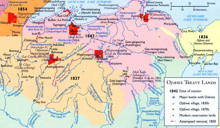
The 1842 Treaty ceded an area rich in copper and iron in
northeastern Wisconsin and the western UP of Michigan. This "Copper Treaty"
allowed mining companies to exploit the ore bodies. Although Native Americans
had carried out small-scale copper mining for centuries, the Ojibwe who signed
the treaty were more interested in retaining their ways of life elsewhere.

Source: Atlas of Michigan, ed.
Lawrence M. Sommers, 1977.
The completion of a canal around the Soo Rapids facilitated the copper rush
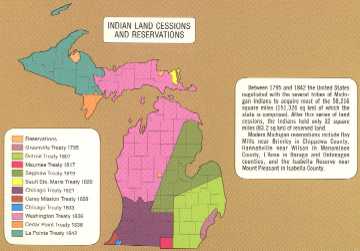
into the region in the late 1840s. The map below shows the dates and
areas of the various Indian cessions in Michigan, in their entirety.

Click here for full size image (255 kb)
Source: Atlas of Michigan, ed. Lawrence M. Sommers, 1977.
The story of the Treaty of Saginaw illustrates the manner in which
these Indian land cessions were often secured. The incentive for the treaty
came from individuals who had visited the Saginaw Valley, believed the area
had a great future, and hence were ambitious to secure lands for settlement
or speculation. They made their desires known in Washington, and Michigan’s
Governor Cass was then instructed to negotiate the desired treaty. Cass then
sent word for the Ottawa and Chippewa to meet with him near the junction of
the rivers flowing into the Saginaw. The date set was the full moon in September,
a time when the Indians had gathered their harvests but before they had set
out on winter hunting. Two ships were loaded in Detroit with provisions and
liquor for distribution at the proper time, and soldiers were put aboard
to protect the negotiators. A council house, which consisted of a roof of
boughs supported by trees, the sides and ends left open, and in the middle
a long platform with rustic benches for Cass and the other officials, was
constructed at the site. Cass arrived on September 10, 1819, with a staff
of assistants and interpreters. Preliminaries lasted for about two weeks,
during which time anywhere from 1,500 to 4,000 Indians assembled. Cass started
with a lengthy speech, with necessary pauses for translation by interpreters.
In his remarks he made known the extent of the lands that he desired to purchase.
Indian orators replied at length, and meanwhile the Indians pondered the
question of whether they would cede their lands.
The tract Cass proposed to buy from the Indians consisted
of some six million acres---nearly one-sixth of Michigan’s total land area.
The Indians would receive a lump sum of $3,000 in cash, and an annual payment
of $1,000 plus "whatever additional sum the Government of the United States
might think they ought to receive, in such manner as would be most useful
to them." The government also agreed to furnish the Indians with the services
of a blacksmith and to supply them with farming implements as well as teachers
to instruct them in agriculture.
The treaty was then signed. To celebrate the occasion,
Cass authorized five barrels of whiskey to be opened and the contents distributed
among the natives.
It is not entirely correct to assume that the US paid the Indians
little or nothing for their land. Up to 1880 the total cost to the United
States government of the public domain acquired from the Indians amounted
to $275 million, and the surveys of the land cost another $46 million. Total
receipts from the sale of these lands to that date were $120 million less
than these expenditures. The Indians received for their lands cash, goods,
and promises, and often the government agreed to pay annuities to a tribe
over a period of years.
INDIAN TREATIES WITH THE U.S. GOVERNMENT
(Between 1795 and 1842, Michigan Indians essentially gave up the state.)
TREATY NAME DATE AREA OF CONCERN
Greenville 1795
Detroit area.
Detroit
1807 Southeast Michigan.
Maumee
1817 Most of today’s Hillsdale County.
Saginaw
1819 Alpena-Lansing and east
Sault Ste. Marie 1820 Eastern Chippewa
County in U.P.
Chicago I 1821
Southwest corner of Michigan. Equivalent in size to Detroit treaty of 1807.
Carey Mission 1828 Most
of today’s Berrian County in the extreme southwest corner of Michigan.
Chicago II 1833
In today’s Berrian County
Washington 1836
Western half of northern lower peninsula of Michigan and the upper peninsula
east of and including Alger and Delta Counties.
Cedar Pint 1836
Today’s Menominee County and part of Delta County.
La Point
1842 The upper peninsula west of Alger and Delta Counties.
Ojibwe cessions
At first, American settlers avoided the northern Ojibwe
country, preferring the farming areas to the south. The Canadian Shield underlies
most of the region, which has mainly infertile soil, conifer forests, swamplands,
acid granite bedrock, and shallow, rocky soils. That combination did, however,
make it inviting for resource extraction, and soon the appeal of this land
prompted Americans to go after it with as much zeal as other lands in Michigan.
When forced migration of Indians began, some escaped to Canada, while others,
in scattered bands, moved north or west before the advancing settlers. The
remaining Chippewa, Ottawa, and Potawatomi gravitated toward the Upper Peninsula
and the northern part of the Lower Peninsula, where, for a while, the pressure
upon them was less intense than in the more densely populated counties. Here
the broken remnants of the tribes endeavored to adjust themselves to their
altered status. They did odd jobs and made souvenirs; they fished and hunted,
usually to supply their own needs, sometimes for commercial profit. Many
retired to a dispiriting existence on reservations, which, until a recent
date, were indifferently managed.
This material has been compiled for educational use
only, and may not be reproduced without permission. One copy may be
printed for personal use. Please contact Randall Schaetzl (soils@msu.edu)
for more information or permissions.