The clash between Ohioans and Michiganians that took place in 1835 has been called the "Toledo War". Since the city of Toledo was not chartered until 1837 and since the fracas was not actually a war, the term "Toledo War" is a misnomer. Because this issue is quite complicated, here's the "Cliff Notes" of the Toledo War:
| Statehood was snagged on a bitter dispute about Michigan’s southern boundary. The question became hot after Ohio revived it in 1832 by deciding to create a city (now Toledo) at the mouth of the Maumee River in the "Toledo Strip." Both Michigan and Ohio called out the militia and issued thundering proclamations in the comic-opera "Toledo War." The country was amused, but the administration at Washington squirmed with embarrassment and hastily dispatched peace commissioners. An act of Congress in 1836 admitted Michigan on condition that the Upper Peninsula be accepted instead of the "Toledo Strip," which would be awarded to Ohio. The administration of President Andrew Jackson could hardly risk offending the Buckeyes with a national election just around the corner! The Michigan Constitutional convention had tried to head off losing the "Toledo Strip" by publishing an appeal to the American people. But it was a losing battle, for Michigan could scarcely win against the dominant influence of the state of Ohio. Her claim was rejected, and the only consolation was the unwanted Upper Peninsula (which later, however, proved to be a bonanza of timber and iron ore). |
T
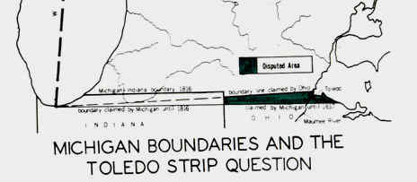
he Ordinance of 1787, which created the Northwest Territory, no fewer than three and no more than five states could be made from the area. If five states were created, they were to be divided in two tiers separated by an east west line at the very south of Lake Michigan. So this issue was abundantly clear. The land without a doubt belonged to Michigan. However, the maps that were used during that day incorrectly showed Lake Michigan to be much farther north than it actually is. Because of this, the line that was drawn at the southern end of the lake would make Toledo part of Ohio, although wrongly. After the fact, maps would show Toledo to be where it rightfully belonged, which is in Michigan.The reason that this strip of land was so debated and wanted by both Michigan and Ohio was because Toledo was the planned end point of the Miami and Erie canals. The whole crisis of the Toledo Strip reached its’ height during the 1830’s when this canal was being constructed. It was becoming more aware how rich the region was agriculturally, and by the early 1820’s, it was clear that the potential for agricultural production couldn’t be fulfilled without better transportation. In 1825, legislature passed laws to build navigable canals. The strip of land was narrow, but Toledo was located conveniently on the mouth of Lake Erie. So, both places clearly wanted this land, as small as it was.
The crucial issue of this "war", so far as Ohio was concerned, was whether the
mouth of the Maumee River (then called the Miamis of the Lake) should be in Ohio or
Michigan. Numerous projects for the building of canals were being advanced, and the outlet
of one entire system of such canals would be the Maumee River. In sum, the state of Ohio
had envisioned that the city of Toledo would be a major metropolis, connected via canals
to the Mississippi, and thus they did not want to lose this city (or the Maumee River
mouth) to Michigan.
The origin of the dispute between Michigan and Ohio dated back to the
Ohio constitutional convention of 1802. There is a story to the effect that a hunter who
happened to be present asserted that the southern end of Lake Michigan was actually
further south than was indicated on the maps of the time.
Congress admitted Ohio to the Union in 1803 under this constitution but
with no specific assent to the change stipulated in the boundary proviso. In 1805, when
the territory of Michigan was established, Congress provided that its southern boundary
should be that set forth in the Northwest Ordinance, completely disregarding Ohio’s
claims. The Northwest Ordinance originally stated that the northern boundaries of
Indiana and Ohio was to be the southern tip of Lake Michigan.
Ohio became a state in 1803. Note that, the map below shows the
city of Toledo (at the "smudge" on the map below) as being in the state of
Ohio. Note also that the northern boundary of Ohio (if extended to the west) appears
not to intersect the southern tip of Lake Michigan, but to intersect the lake a bit north
of its southernmost point.
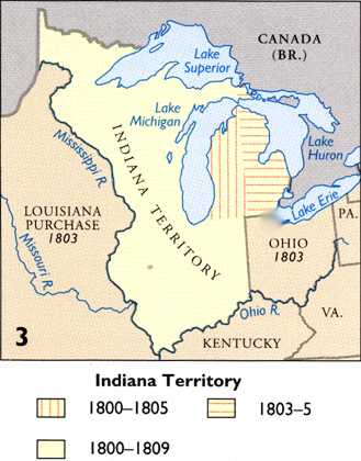
Source: Atlas of Michigan, ed. Lawrence
M. Sommers, 1977.
Eventually, Indiana became a state, and shared the same boundary with Ohio (see map
below).
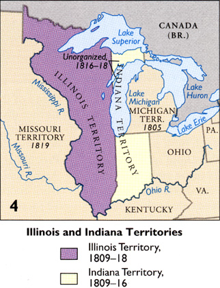
Source: Atlas of Michigan, ed. Lawrence
M. Sommers, 1977.
Ohio’s congressmen continued to agitate for acceptance of the altered northern
boundary of their state, but despite their efforts, in 1812 Congress passed a resolution
providing for the survey of the ordinance line drawn due east from the southerly extreme
of Lake Michigan. The War of 1812 forced the survey to be delayed until 1817. By that
time, a former Ohio governor, Edward Tiffin, was the surveyor general of the United
States. He employed William Harris to survey the boundary, but instructed him to run the
line in accordance with the provision of the Ohio constitution (that is, NOT drawn due
east from the southern tip of Lake Michigan). Governor Cass of Michigan immediately
protested that Tiffin was not carrying out the instructions of Congress, and as a result a
second survey was made in 1818 by John A. Fulton, this time in accordance with the
provisions of the 1787 ordinance. This second, correct, survey line intersected Lake Erie
east of the mouth of the Maumee, leaving the river’s outlet in Michigan. The area
between the Harris line on the north and the Fulton line to the south, commonly called the
"Toledo strip," was about eight miles wide on the east, five miles wide on the
west, and contained 468 square miles.
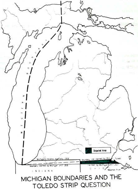
Source:
Unknown
The land in question was a strip about seven miles in width, at the
very southern boundary of what is now Michigan. Michigan, still a territory, claimed the
Toledo strip, an area along its border with Ohio near the Maumee River (look at the 1805
map below). Ohio, which was already a state, also claimed the land. The
"Toledo War" broke out between these two states, over this strip (the
"Toledo Strip").
The fight between Michigan and Ohio politically was a very unequal one.
In 1817, the state of Ohio had two senators and six representatives in Congress, while
Michigan Territory had not a single one. Even at the end of the struggle, Ohio had two
senators and nineteen representatives, while Michigan had only one delegate who could
politically speak, but couldn’t vote. This basically shows that Ohio’s plea for
the strip of land was heard in a much louder voice than Michigan’s was. It’s
quite ironic that the land rightfully should have been Michigans’, but putting that
fact aside, that politics and the fact that Michigan hadn’t entered the Union as a
state made it so that Ohio became the victor.
The United States Congress had to settle the border dispute, however,
before making Michigan a state. In settling the dispute, Congress passed the Northern Ohio
Boundary Bill, which (1) gave Ohio the Toledo strip. (2) gave Michigan the western part of
the Upper Peninsula, and (3) cleared the way for Michigan to become the nation's 26th
state on January 27, 1837. The maps below show the two areas involved in the
settlement of the dispute.
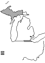
Source: Unknown
Here are some of the details of this controversial boundary "war".
Michigan’s Governor Cass tried to negotiate a compromise with Ohio that would
permit that state to retain the mouth of the Maumee while conceding to Michigan additional
territory elsewhere in northwestern Ohio, but the effort came to naught. Someone
discovered some technical shortcomings in the Fulton survey, and a new one was ordered.
This time the line was run by Captain Andrew Talcott. The Talcott line, when run,
coincided with the Fulton line. Meanwhile in Washington, the Senate, after a lengthy
debate, passed a bill upholding Ohio and accepting the Harris line as the official
boundary. In the House of Representatives, however, the bill encountered stiff opposition
and was referred to a committee, where it still reposed when Congress adjourned.
In the next session of Congress, beginning in December 1834,
Ohio’s senators revived the boundary bill, and this time added a section confirming
the northern boundaries of Indiana and Illinois, which, when these states had been
admitted in 1816 and 1818, had been pushed far south, beyond the line specified by the
Northwest Ordinance. There was no necessity to reaffirm these boundaries, but the Ohioans,
by including such a provision in the bill to establish Ohio’s northern boundary at
the Harris line, sought support from their neighbors to the west. There was an inference
that if Michigan were to make the ordinance line stick in its dispute with Ohio, then the
Indiana and Illinois line might be of questionable legality.
The danger of an armed clash between Ohioans and Michiganians now
became a matter of concern to President Jackson. He sought the opinion of his attorney
general, who upheld Michigan’s claim. This was no comfort to Old Hickory, who had his
eye fixed on the next election and worried no end about all those votes his party would
lose in Ohio, Indiana, and Illinois if he came out in support of Michigan. Not knowing
what else to do, Jackson appointed two commissioners to go west and try to settle the
controversy. They went first to Detroit and saw Michigan Governor Stevens Mason, who said
he would refrain from using force as long as Ohioans stayed out of the disputed strip.
When they transmitted this proposal to Lucas, he naturally rejected it.
Mason was not bluffing. At the head of his militia, he had arrested
nine surveyors who were re-marking the Harris line for Ohio. The rest of the surveying
party was permitted to escape, the retreat of its members being speeded by the firing of a
gun high over their heads.
It is surprising that no one was killed in the clashes between the two
sides. Miraculously there were no casualties, with the single exception of a Michigan
sheriff who was stabbed in a tavern scuffle by an Ohioan named Two Stickney. He was the
son of B.E. Stickney, an ardent Buckeye who fancied himself a military genius. His two
sons were named, respectively, One and Two. In spite of the fact that no one was killed,
the rumors that circulated through Ohio depicted Michiganians as bloodthirsty villains of
the deepest dye. One explanation for the origin of the name "Wolverines" for
Michiganians is that it was invented by the Ohioans as a suitable nickname, since the
wolverine has the reputation of being a particularly vicious and ornery animal.
From this committee there emerged, in due course, a compromise that
called for the acceptance of the Harris line to satisfy Ohio, but gave to Michigan a large
area in what is now the Upper Peninsula. This compromise may have been suggested by the
feeling in some quarters that the fifth state to be carved out of the Old Northwest would
be too large. Acceptance of the compromise was foreshadowed in April 1836, when the
territory of Wisconsin was established by law with its northern boundaries fixed along the
line of the Menominee and Montreal rivers. But the debate on the admission of Michigan to
the Union dragged on. The bill carried 143 to 50 and was signed by President Jackson on
June 15. It meant that Michigan would be admitted into the Union if it's people would
accept the boundary compromise.
Sentiment against the proposed compromise was almost universal at
first. A resolution adopted in March had dismissed the area that Michigan was to receive
as a "sterile region on the shores of Lake Superior, destined by soil and climate to
remain forever a wilderness." The Detroit Free Press called it "a region
of perpetual snows---the Ultima Thule of our national domain in the north."
Senator Lyon said the region could furnish the people of Michigan with Indians for all
time and now and then a little bear meat for a delicacy, but he was nevertheless one of
the few who thought that Michigan might eventually find it got the better of the bargain.
There was resentment of the fact that Arkansas had been granted statehood unconditionally
the same day that Michigan had been offered admission only on conditions that most
Michiganians regarded as disadvantageous to the state.
If Michigan did not want the huge area in the northland that Congress
offered, it is equally true that some of the residents of the Upper Peninsula did not want
to be part of Michigan either. Congress had received a number of petitions from persons in
this region asking that the area south of Lake Superior be organized as the territory
of Huron. Michigan Territory, as originally established in 1805, had included the
eastern Upper Peninsula, including the settlements at the Straits of Mackinac and at Sault
Ste. Marie. These areas had been represented in the 1835 convention that drafted
Michigan’s constitution and had defined the new state’s boundaries so as to
include these parts of the Upper Peninsula within that state. Thus the statement that
Michigan received the entire Upper Peninsula in return for surrendering the Toledo strip
is not correct, but nevertheless the error continues to be perpetuated. It was
approximately the western three-quarters of the Upper Peninsula that was involved in the
compromise. Some people in the eastern section preferred to become part of the proposed
Huron Territory, pointing out that Sault Ste. Marie was cut off from Detroit for six
months each year and claiming that the region was treated by the rest of Michigan as a
remote and neglected colony. Congress, however, paid no attention. Politics was more
important than geography, and Michigan was saddled with the problem--never satisfactorily
resolved--of uniting two areas which nature, for many thousands of years, has set asunder.
Delegates took only two days to pass a resolution accepting the
congressional offer, with all but 10 of the 72 delegates signing the resolution. Opponents
dubbed the meeting the "Frostbitten Convention."
When the resolution of assent reached President Jackson he promptly
sent it on to Congress with a message stating that Michigan had "complied with the
regulations of the conditional act of admission." A bill to admit Michigan into the
Union was duly presented.
Of course, President Andrew Jackson realized that an armed collision
could occur. So, the federal government took it upon itself to be the peacemaker and patch
up the dispute. To settle it, a "compromise" was proposed to the two governors.
However, this wasn’t much of a compromise. Under the compromise, Michigan was to
discontinue its’ prosecutions under the act of February 12, 1835 which was an act to
prevent foreign jurisdiction within the limits of Michigan Territory. Also, no new
prosecutions could be made and no forcible opposition be made. The real catch of this
so-called compromise was that the "Harris line", the line that Ohio claimed to,
was to be run and re-marked by the authorities of Ohio, without any interruption from
Michigan.
The boundary dispute with Ohio that had held up Michigan’s
admission continued to be a subject of controversy. Not until 1915 was the land boundary
satisfactorily surveyed and marked. At that time a ceremony was held in which the
governors of the two states, standing on either side of the boundary, exchanged handshakes
(below). Questions still remained, however, regarding the location of the boundary in Lake
Erie as it angled off in a northeasterly direction from the north cape of Maumee Bay to
the international boundary with Canada. In the 1960s the state of Michigan went to court
to try to prove its claim to a larger share of Lake Erie’s waters, largely because of
a belief that valuable deposits of oil and gas might be discovered beneath these waters.
In 1973, however, the United States Supreme Court upheld an earlier United States Circuit
Court of Appeals ruling that had rejected Michigan’s claim and had awarded some 206
square miles of Lake Erie waters and bottomlands instead to Ohio. Presumably this marked
the conclusion of what had threatened to be an interminable boundary dispute.
Sure, Michigan did "lose" to Ohio in a way. At the time, we
didn’t get what we wanted, the Toledo Strip, and they did. However, as a state we
never really lost anything. While Toledo was conveniently located on the water, we still
had Detroit, which was and continues to be the center of industry here in Michigan. We
lost a little bit, but gained tremendously. At the time of statehood, surely the acquiring
of the Upper Peninsula was thought to be a disadvantage. Time proved to tell that it was
nothing like that at all. We really lost nothing, and gained immense mineral wealth,
fortune from logging, and vast natural beauty.
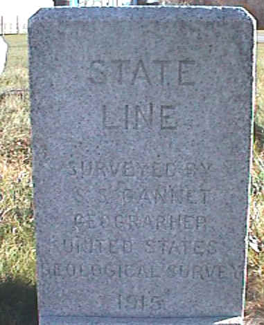
Source: Photograph by Randy Schaetzl, Professor of Geography - Michigan State University
So, while at the time, Michigan considered the loss of the Toledo Strip
a failure, it seems that the Upper Peninsula more than made up for this loss. The Upper
Peninsula proved to be rich in terms of lumber, copper, and iron ore, not to mention the
value of it’s beautiful, rustic land.
Some of the text and images in this page have been modified from C.M. Davis’ "Readings in the Geography of Michigan" (Ann Arbor Publishers).
This material has been compiled for educational use only, and may not be reproduced without permission. One copy may be printed for personal use. Please contact Randall Schaetzl (soils@msu.edu) for more information or permissions.