LAKES, RIVERS AND WETLANDS
Rivers provide natural surface drainage and are used for transportation and recreation; in
some cases, they also supply fish as a source of food. Rivers and streams are also used to
take away domestic and industrial waste. The daily outflow of either the Grand or the
Muskegon Rivers--the state’s largest rivers in volume and size of drainage
basin--could meet the domestic water needs of the entire state. Rivers in the Lower
Peninsula are normally much longer and have larger drainage basins than those in the Upper
Peninsula.
The rivers that form parts of Michigan’s boundaries are also
important for transportation. These include the St. Marys River in the Upper Peninsula and
the St. Clair and Detroit Rivers in southeastern Michigan, between the Lower Peninsula and
Ontario, Canada. The St. Marys River flows from Lake Superior to Lake Huron and is
controlled by the Soo Locks, built between 1853 and 1855. These locks allow lake
freighters to negotiate the 22 ft (6.7 m) of difference between the levels of the two
lakes. The Soo Locks on the St. Marys River carry about 90
million tons of cargo per year, an amount that rivals the annual traffic on the Panama
Canal when one considers that the Soo Locks are frozen shut part of the year. The St.
Clair River, the Detroit River, and Lake St. Clair are important links in the St. Lawrence
Seaway. The city of Detroit is the principal generator of water traffic in Michigan, but
ports all along Michigan’s coastline contribute to the commerce of the Great Lakes.
Iron ore is the chief product carried south, and coal north, through
the western Great Lakes. Limestone, a bulky material used in the steel, sugar, and road
construction industries, is carried south through the Great Lakes from quarries such as
those at Rogers City in Presque Isle County and at Petoskey in Emmet County. Manufactured
products from all over the world are shipped through the Michigan ports of the St.
Lawrence Seaway. The river portions of the St. Lawrence Seaway in Michigan are normally
frozen from late December to early April, which restricts transportation.
Most Michigan rivers are rather slow moving streams, particularly those
in the southern half of the Lower Peninsula. In the Upper Peninsula, there are a number of
rapids and waterfalls, of which the two Tahquamenon Falls, 50 ft high, are the most
famous. Some of the more rapid-flowing and larger rivers have been dammed to create
hydroelectric power--for example, the Manistee, Pere Marquette, Muskegon, Grand,
Kalamazoo, and Au Sable (below). The water collects in basins behind the dams and is
controlled in order to provide the even flow desirable for the production of hydroelectric
power.
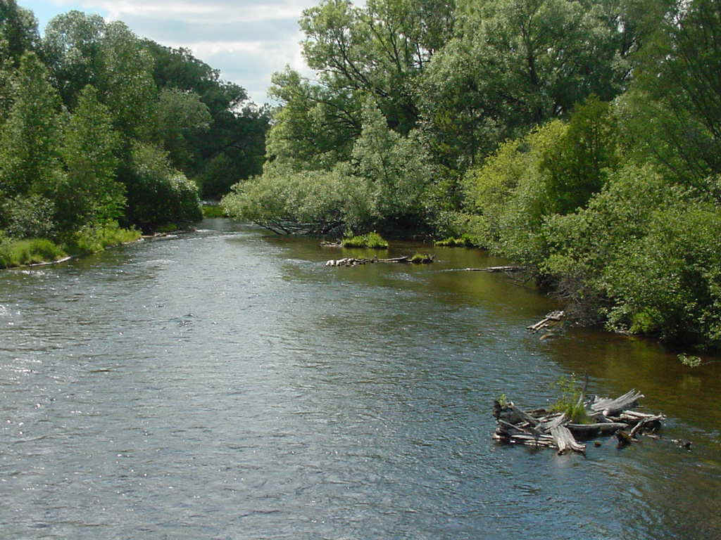
Source: Photograph by Randy Schaetzl, Professor of Geography - Michigan State University
The slow flow makes for pollution, especially in the heavily populated
southern part of the state, and many industries are big contributors to that pollution.
Millions of dollars are being spent annually to improve the quality of the water in
Michigan’s rivers by reducing the amount of pollution.
The beauty of Michigan’s rivers and river valleys is one feature
that makes the state attractive to tourists. But even in the recreational use of streams
there are conflicts, for example, between trout fishermen and people who wish to use the
river for canoeing.
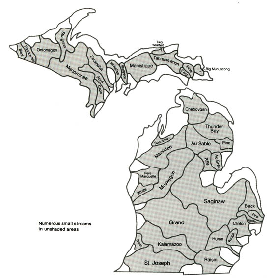
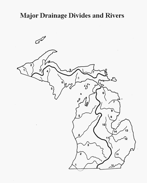
Michigan's major rivers are shown in the map below.
Source: Unknown
KEY
Upper Peninsula Rivers and their watersheds
1: Presque Isle River
2: Ontonagon River
3: Sturgeon River
4: Michigamme River
5: Menominee River
6: Escanaba River
7: Tahquamenon River
8: Manistique River
Lower Peninsula Rivers and their watersheds
1: St. Joseph River
2: Kalamazoo River
3: Grand River
4: Muskegon River
5: Manistee River
6: Black River
7: Thunder Bay River
8: Au Sable River
9: Rifle River
10: Tittabawassee River
11: Shiawassee River
12: Flint River
13: Cass River
14: Saginaw River
15: Huron River
16: River Raisin
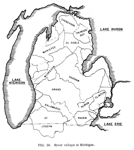
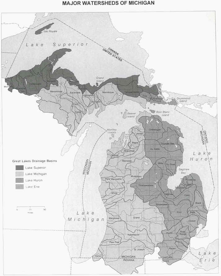
The map below shows only the watershed boundaries for some of the important
lower peninsula rivers. Remember! The lines show the outer limits
of the watersheds, NOT the river channel.
Source:
Unknown
Below are more complete maps of the major watersheds of Michigan:
Source:
Unknown
Source:
Unknown
Major Rivers in Michigan
The Saginaw River
River basins, catchments, or watersheds are the basic unit for water management. The
Saginaw basin, for example, is a pear-shaped area comprising 6,260 square miles of
drainage and containing urban populations in Flint, Midland, Bay City, and Saginaw. It is
the largest system in Michigan. The Saginaw River itself is relatively short, only 20
miles in length with a low water flow so small that it is not unusual at the time of
strong upstream winds for the direction of river drainage to be reversed. The river is in
fact only the outlet channel for four tributaries that junction within a few miles of each
other-the Tittabawasee, the Flint, the Cass, and the Shiawassee. The tributary streams to
the Saginaw, thought not large, are swift, falling 300 to 600 feet in their lengths of 40
- 80 miles. The Saginaw, or outlet, lies entirely in flat plain land so that serious
problems of flood exist in late spring and equally serious problems of pollution exist in
the slack season. These risks have been largely solved by going to Saginaw Bay for
municipal supplies and by dredging additional canals for flood control. The pattern of
solution is already set and there is no reason to anticipate difficulty in maintaining
adequate control.
The main tributary of the Saginaw is the Tittabawassee, rising in the
southeastern part of Roscommon County and flowing southerly through Midland to junction
with the Saginaw River just above the City of Saginaw. The Flint River is the next largest
tributary of the Saginaw, rising in Lapeer and Oakland Counties and dripping 320 feet in
its 80 miles of length. It serves the city of Flint but no other large urban centers. The
stream’s flow is not rapid but it is well protected from pollution. The Shiawassee,
draining the Howell and Owosso area and the Cass, which serves only small centers in the
thumb complete the tributaries of the Saginaw basin. Improved farm land comprises the bulk
of the area drained by these relatively small streams.
The Grand River
The Grand River Basin is the second largest drainage system in the State. It has several
major tributaries, the Thornapple, the Maple, and the Flat, and a number of minor ones,
the Looking Glass, the Rogue, and the Red Cedar. The basin lies in the center of the
State, is about 135 miles long and 70 miles wide, draining 5,572 square miles. The main
stream rises in Hillsdale county and flows northerly through Ionia to Grand Rapids and its
outlet at Grand Haven on Lake Michigan. The major tributaries merge with it near Ionia in
the relatively flat area west of Grand Rapids. From the points of junction to Lake
Michigan the stream falls only 50 feet in a distance of 80 miles in contrast to falls of
350 feet in the tributaries. Consequently the lower portion of the river, including the
Grand Rapids area, is subject to flooding.
The worst flood on record in Grand Rapids occurred in 1904 when the
river rose 9 feet above the danger line, displace 14,000 persons and produced over $2
millions in damages. Flood control works were established thereafter that are adequate to
protect against a similar occurrence. Fortunately, the likelihood of such extreme
conditions is not very great. The usual causes of flooding are early freezing of ground
water in the fall, heavy snowfall, followed by a quick and sustained rise in the spring
temperature before the ice is fully out of the main channel. The likelihood of heavy
precipitation accompanying this condition is not very great.
There is no shortage of water in the basin, either from ground or
surface sources. The water is hard and somewhat mineralized, but is capable of treatment
of either industrial or municipal purposes.
The City of Grand Rapids currently obtains its supply from Lake
Michigan by pipeline as do other cities on the lake shore. The water rates in Grand Rapids
compare favorably with those of other large cities despite the distance over 20 miles that
its water is pumped.
The Kalamazoo River
Just south of and parallel to the Grand River is the Kalamazoo. It is a long and narrow
basin, 100 miles by from 10 to 30 miles. It is densely populated, serving the cities of
Albion, Battle Creek, Marshall and Kalamazoo. The river falls over 500 feet in its length
of 125 miles and is not dangerously subject to flooding. The flow is not large, but is
adequate with adjacent ground water sources to supply industry and municipalities.
The chief problem affecting the Kalamazoo basin is the provision for
waste disposal of the paper industry which is located in its central portion. In the past
chemical pollution has been extreme and the remedies have been expensive. At the present
time the pressure of industrial waste and municipal discharge will occasion still further
heavy outlays for control.
The paper and pulp industry is a heavy consumer of water located on the
Kalamazoo River. Originally all pulp and paper mills were located on larger rivers down
which logs were driven; these rivers supplied ample power, process water and disposal of
waste. New methods of generating and transmitting power and new methods of transportation
have altered the situation. The Kalamazoo industry has survived because its transportation
costs are favorable and because it has adequate process water supplies. It specializes in
high quality paper suitable to its location.
The paper industry is one of the few industries for which excellent
data on water consumption are available. Truly enormous quantities of water are required
in the production of pulp but such mills are not located in the industrialized portion of
lower Michigan. Paper mills proper, such as those in Kalamazoo, use more moderate amounts
and can be remarkably flexible in their requirements through recirculation of the
"white water". There is no reason to believe that water supply limits a moderate
expansion of the finished paper industry in Michigan although there is no reason to
suppose that a new industry will arise in other locations in the lower part of the state.
The St. Joseph River
In the southwestern corner of the State lies the St. Joseph Basin, two thirds of which is
in Michigan. It is the third largest of Michigan’s river systems. The upper portion
of the river from Hillsdale County to the Indiana line is sparsely populated. The central
portion lies in Indiana and serves the cities of Elkhart and South Bend. The river then
turns northwest to enter Michigan and reach the lakes at St. Joseph.
Pollution is not important in the upper reaches of the river but from
South Bend to the mouth at St. Joseph pollution is excessive. The river has a well
sustained flow with many impounding reservoirs, both natural and artificial. The quality
of the water is suitable for industrial processing and with proper treatment can be
rendered available for municipal use.
Detroit-area rivers
Just north and south of Detroit lie the Clinton and Huron Basins, both emptying into the
Detroit River. Neither stream is large but both perform useful functions for carrying away
the waste products of a fairly dense population. The Clinton serves an area from Pontiac
to Mt. Clemens and the Huron serves chiefly the Ann Arbor and Ypsilanti districts.
Lying between the Huron and Clinton Rivers is the City of Detroit.
Thanks to its location on the Detroit River it is able to furnish unlimited quantities of
excellent water at very low costs and to dispose effectively of the cities’ waste.
There are no large sources of water on the outskirts of Detroit. Wayne
and Macomb Counties lie within the old bed of Glacial Lake Maumee.
The beaches of this ancient lake formed an irregular line running southwest to northwest
through Ypsilanti and Birmingham. To the west of this line are glacial
moraines, till plains and outwash deposits from which ground water can be obtained in
moderate to large amounts. East of the line of beaches and including all of Detroit lie
only flat deposits of glacial lake clay with scattered deposits of sand. The soil within
this two county area is relatively impervious so that even when saturated it is incapable
of yielding much water to wells. Moreover, the rock bed which underlies the soil is
heavily mineralized. In consequence water is not available for large concentrations of
people or industry except from Lake St. Clair or the Detroit River.
The area is not only without ground water supply; it is also deficient
in natural channels to dispose of spent water. The Rouge, its only river, is an
inconsiderable stream except near its mouth when a channel is continuously dredge to keep
it open for navigation. Despite the small flow of the Rouge it is the chief outlet for
Detroit’s waste and only its nearness to the river makes possible the disposal of
waste from an outlet of these dimensions.
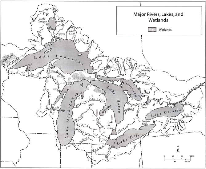
The map below shows both rivers and some of our major wetlands.
 |
|
Source: Unknown
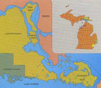
One of the most important rivers to Michigan's history and economy is the St. Mary's River, which connects Lake Superior to Lakes Huron-Michigan.
Click here for full size image (361 kb)
Source: Atlas of Michigan, ed. Lawrence M. Sommers, 1977.
The rapids (or falls) on the St. Mary's were a major obstacle to water traffic, prior to the construction of the Soo Locks. River traffic had to portage around the rapids, making this a spot where people could rest, meet, exchange ideas, and purchase supplies. Thus, it is no coincidence that two cities soon sprung up at this site: the twin Sault Ste. Maries.
Michigan's largest inland lakes
LAKE |
AREA (hectares) |
AREA (sq miles) |
Houghton |
8,113 |
31.3 |
Torch |
7,602 |
29.4 |
Charlevoix |
6,990 |
27.0 |
Burt |
6,934 |
26.8 |
Mullett |
6,735 |
26.0 |
Gogebic |
5,419 |
20.9 |
Black |
4,103 |
15.8 |
Manistique |
4,103 |
15.8 |
Crystal |
3,933 |
15.2 |
Portage |
3,904 |
15.1 |
Higgins |
3,888 |
15.0 |
Fletcher Pond |
3,633 |
14.0 |
Hubbard |
3,584 |
13.8 |
Leelanau |
3,370 |
13.0 |
Indian |
3,240 |
12.5 |
Elk |
3,131 |
12.1 |
Michigamme Reservoir |
2,916 |
11.3 |
Glen |
2,537 |
9.8 |
Grand |
2,292 |
8.8 |
Long |
2,289 |
8.8 |
Parts of the text on this page have been modified from L.M. Sommers' book entitled, "Michigan: A Geography".
This material has been compiled for educational use only, and may not be reproduced without permission. One copy may be printed for personal use. Please contact Randall Schaetzl (soils@msu.edu) for more information or permissions.
