SEDIMENTARY ROCK SEQUENCE IN THE MICHIGAN BASIN
How did the early Precambrian sedimentary (and other sedimentary) rocks form?
Changes in temperature caused rocks to weather, while, gravity and moving waters carried
the loosened rocks down the slopes, rolled them together, broke them into smaller and
smaller particles, carried them to the sea where they became sediments that muddied the
sea water. Some of the sediments were dissolved in the water, and as the process kept on
through the ages the seas became salty. The sediments, sorted by waves and currents of the
first oceans, settled to the bottom of the seas and were spread out on the sea floor. In
the course of a long time, as layer upon layer of sediments were piled one on another,
they were compressed, cemented, and consolidated into rock which we call sedimentary. Each
layer or bed is a stratum; layered or bedded rock is said to be stratified.
Various minerals in the ancient igneous rocks were made over into
different sediments. The hard minerals like quartz collected together as sand, and being
heavy, were not carried so far out to sea. They built up coarse and fine rocks which we
call sandstones. Other minerals were broken up into fine clay and silt muds that were
carried far from shore but eventually settled on the sea floor and compacted to a rock we
call shale. Some of the minerals disintegrated to form lime, or calcium carbonate. As the
igneous rocks were eroded some minerals dissolved and were carried to the sea in solution;
there certain chemical reactions caused the lime to be precipitated and in places to build
up great thicknesses of lime mud that eventually solidified into a rock known as
limestone. Other chemical reactions caused iron minerals to be formed which in turn
settled to the bottom of shallow seas, and later in the geological history gypsum and salt
crystallized out of the sea water to form great beds of gypsum and rock salt.
The Michigan basin was a major area of deposition of such sediments,
beginning about 600 million years ago, during the Cambrian Period, and lasting up to the
Jurassic--some 200 million years ago. For the 350 million years of the Paleozoic
era, the time of ancient plants and animals, nature’s quiet forces of erosion were at
work, gnawing away at the old Precambrian mountains and carrying the sediments to the
seas. Seven times the seas alternately spread over and retreated form the land causing
seven new sets of conditions for the formation and deposition of sediments, each time
changing the conditions under which plants and animals lived and died. Thus seven sets (or
systems) of sedimentary (or stratified) rocks were laid down, one on top of the other, in
the shallow seas that covered the continental blocks. These movements of the seas were
world wide events, sediments were laid down in all parts of the world, therefore, although
the rocks first studied in England and Wales were named for places and early peoples of
the British Isles, we carry the names wherever similar rocks with similar records of life
and of nature’s processes are found. These periods are the Cambrian, Ordovician,
Silurian, Devonian, Mississippian, Pennsylvanian, and the Permian. The general
structure of the basin is shown below.

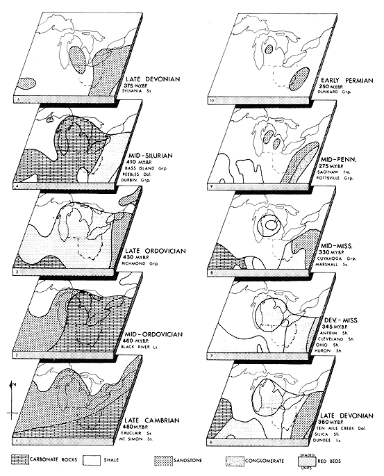
As the map sequence below shows, the Michigan basin began to form about 500 million
years ago, during the early Ordovician. Sediments, mostly sands, were being
deposited here, however, starting as early as 600 million years ago. This period,
the Cambrian, was a time when great thicknesses of sandstones were forming.
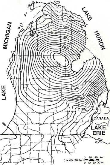
The map below shows the thicknesses of these sandstone rocks (in feet) formed during
the middle Cambrian. All of the sediments laid down during this period were sandy,
such that they eventually formed sandstones (in the Mt. Simon, Eau Claire, and Galesville
Formations). Note the slight beginnings of a basin, centered around Gladwin County.
By the late Cambrian and Early Ordovician, depositional patterns remained somewhat the
same, as indicated on the map below. Note, however, that the shape of the basin
shows up nicely by now--the Early Ordovician. Also by now, the rock types, although
dominated by sandstones (Franconia and Trempealeau Formations), begin to show an influence
of deeper water sedimentation. By the early Ordovician, the Prairie du Chein
dolomite rocks form, and in the map below the thickness of the Prairie du Chien dolomite
is added to the two Cambrian sandstones to yield rock thicknesses in excess of 2500 feet
for parts of Michigan!
By the middle Ordovician, ...
Need info here on Sulurian....
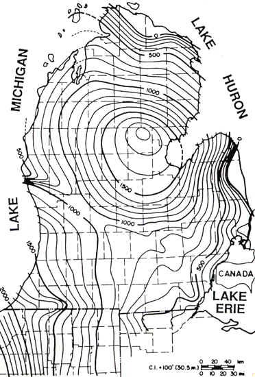
During the Silurian, the rock depositional patterns were not much
changed from those of the Cambrian. Again, the center of the basin was located right
around Gladwin and Iosco Counties (see maps below).
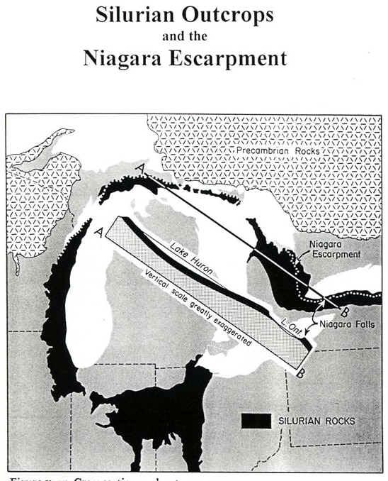
Outcrops of Silurian rocks today follows the prominent Niagara
escarpment, or cuesta. The map below shows where these rocks today form the
uppermost bedrock.
Even in these early warm seas another force was at work building rocks. In some way the
first bacteria and one celled plants learned to take lime from the water; they collected
in jelly-like masses. Lime collected on these early plants, layer upon layer, and built up
into great masses of limestone. Later, when animals came upon the earth they were also
one-celled creatures living in the sea, but as they struggled for existence they evolved
to more complex creatures, and in time they also took lime from the sea water to make
protecting external coverings or shells. When these creatures died their shells fell to
the sea floor, accumulated in thick masses, were also broken to lime muds, but all in time
became limestone rock – the cemeteries of the animals which lived in the seas, and
the museums in which the records of past life (fossils) are preserved.
The extensive development of offshore carbonate rocks and an absence of
sandstones and shales suggests that no landmass was present in the Great Lakes area.
After the deposition of the late Silurian evaporites in the Michigan
Basin, the midcontinent was uplifted, and The Michigan Basin remained as a small
land-locked sea. When the seas returned again during middle Devonian time they deposited a
wide variety of Devonian sediments in Michigan, including sandstones, shales, limestones,
and evaporites.
The middle Devonian sediments are largely offshore limestones with
excellent development of coral reefs in a number of places such as at Alpena. The upper
Devonian in Michigan and Wisconsin is characterized by deposition of black shales (the
Antrim shale in Michigan) that thicken to the east. These muddy sediments were derived
from erosion of an uplift in the northern Appalachian region. This shale and some
sandstone accumulated to thicknesses totaling over 900 m in the Michigan Basin.

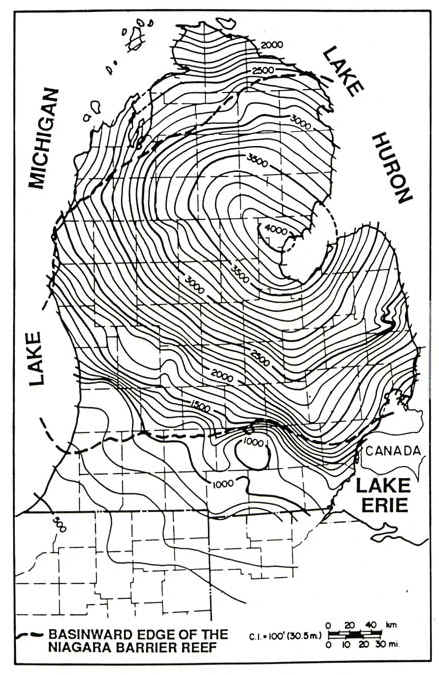
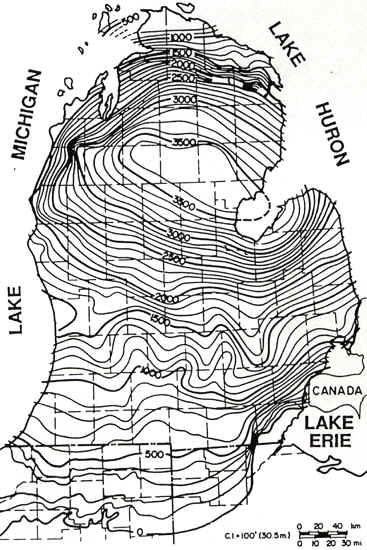
So, just how thick are the Devonian sediments? The map below
shows the thicknesses of sediments (in feet) deposited during the Devonian. Three
things to note from this map are: (1) the tremendous thicknesses (over 3600 feet in the
center of the basin!) of these sediments, (2) how the thickness pattern outlines the shape
of the Michigan basin during this period in geologic time, and (3) the center of the
Michigan basin is around Gladwin-Ogemaw-Roscommon Counties. Recall that, during the
Devonian, most of the rocks that formed were limestones (notably the Rogers City Limestone
and the Bois Blanc Limestone), and shales (notable the Antrim Shale, a big oil and gas producer, and the Ellsworth Shale) in fairly deep
waters.
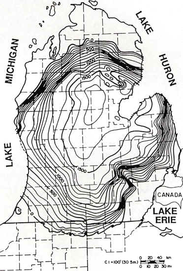
In the next (later) period of geologic time, the Mississippian, sediment depositional
patterns were quite similar, implying that the Michigan basin was still a major depocenter
for, in this case, shales and sandstones. The fact that the sediments were coarser
textured (sands and muds, rather than the muds and limey oozes of the Devonian) suggests
that the basin was getting shallower during the Mississippian. Note, too, that
during the Mississippian, the area of deposition is smaller in size, also implying that
the basin is filling.
Concluding note: The Paleozoic era in the Great Lakes region saw the seas advance over the area and withdraw at least ten times over a period of some 200 million years. The cause for these repeated oscillations of sea level and the development of a series of basins and domes on the continent has, however, remained largely a mystery.
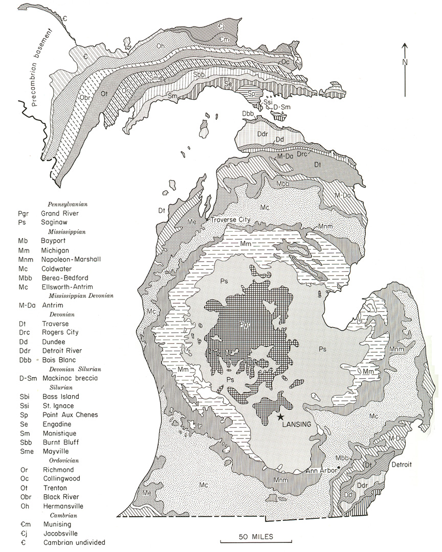
The final result of all this sedimentation (and some erosion) is a series of rock
layers that crop out in concentric circles, as shown on the map below. The rocks are
thickest in the center of the basin, and all dip toward the basin center.
Parts of the text above have been paraphrased from C.M. Davis’ Readings in the Geography of Michigan (1964).
This material has been compiled for educational use only,
and may not be reproduced without permission. One copy may be printed for
personal use. Please contact Randall Schaetzl (soils@msu.edu)
for more information or permissions.
