From 1810 to 1940 the population of
southern Michigan (hereafter designated as Lower Michigan) increased from five thousand to
five million persons. As such changes go, this is a rather amazing rate of increase. The
growth and distribution of population provide the basic historical foundations-economic,
social, and political-for the development of Michigan into the state we know today.
By 1860 Michigan was a democratic community of farmers, artisans, and lumbermen. It was
derived mainly from New England, New York, Pennsylvania, and Ohio, with some immigrants
from Canada, Great Britain, Ireland, Germany, and Scandinavia.
In 1810, 4762 people lived in Michigan territory. By 1820, the population
was 8096, and the three largest towns were Detroit, Mackinac, and Sault Ste. Marie. By
1850, 34% of the population were immigrants from New York State. Michigan fever in the 1830's was fueled by good land and
the Erie Canal, but it was extended due to the copper boom of the 1840's and the iron ore
boom shortly after that. In 1838, the furniture industry began in Grand Rapids, as small
lumber mills began dotting the landscape. Out-migration from 1970-90 totaled nearly
a million people, or 10% of the 1970 population. Why? 1980's recession and loss of jobs.
Michigan’s population growth can be divided into three periods.
The first period covers the years 1810 to 1850, portraying the settlement of the
southernmost counties. The second period, 1850 to 1910, covers the decades of settlement
in the central and northern areas, and of continued growth in the previously settled
southern area. The third period, from 1910 to 1940, highlights the urban dominance of
southeastern counties, the relative stability of the central area, and the decline in
population of the northern area.
FIRST PERIOD
Settlement in the Southern Counties, 1810-1850
Michigan became a territory in 1805. The 4,762 persons counted in the 1810 Federal
census were almost entirely confined to a narrow line of settlement extending north and
south between Detroit and the Maumee River along the eastern shore of Lake Erie and the
Detroit River. Before the end of the decade Federal land surveyors were beginning to open
up land for entry in the southeastern area. Progress in settlement was, however, slow and
discouraging.
By 1830 settlement had spread westward across nearly a third of the
peninsula as well as northward along the Lake Huron shore. Far to the west, in what is now
Cass and St. Joseph counties, small settlements were being established by migration out of
Indiana.
The first census in 1834 revealed a population of some 60,000,
distributed in fourteen organized counties: four along the east shore, St. Clair, Macomb,
Wayne, and Monroe; three immediately to the west, Oakland, Washtenaw, and Lenawee; six in
the southwestern area, Berrien, Cass, St. Joseph, Branch, Calhoun, and Kalamazoo; and
Jackson, in between, associated with the eastern rather than with the western counties.
Wayne County led in population in 1834 with 17,000.
A remarkable change, however, had occurred by 1840 in both population
growth and distribution. The increase in population for the decade 1830-40 was 175,000, or
547%. The decade of the 1840's brought another great increase for the southern area as a
whole, greater than the previous record of the 1830's.
During this first period of settlement, ending in the year 1850, the
lower peninsula had grown by about 390,000. The population of the southeastern area was
exactly twice as large as that in the southwestern area. The population of the central
area had increased from less than 1000 in 1840 to nearly 7,000 in 1850. The 21 counties
constituting the northern area had a scattered population of less than 2,000, including a
settlement area in the Grand Traverse region.
During this period of settlement and growth, there was instituted a
$5,000,000 state internal-improvement program for roads, canals, and railroad
construction. Also, these decades had seen the rapid organization of townships, counties,
and villages.
SECOND PERIOD
Northward Settlement and Southern Growth, 1850-1910
Two distinct trends are to be observed in this second period. First, the counties of
the central and northern areas became settled, and the pioneer stage flourished for some
40 years, after which the frontier gradually closed. This development was contemporary
with the rise and decline of the pine forests. Second, the population of the southern
area, which had already passed from the pioneer stage, was becoming more settled,
accompanied by a continuation of heavy gains.
The central and northern areas made their most spectacular gains during
the 30 or 40 years of pioneer settlement. The 30 years from 1860 to 1890 were boom days of
lumbering on the Saginaw, when some 270,000 persons were added to the population of this
Saginaw Valley-"Thumb" district. The lumber boom in west-central Michigan
brought in about 165,000 persons.
In the central area as a whole the period of rapid population increase
tapered off by 1890, coinciding with the decline of the lumber industry on both the
Muskegon and the Saginaw Rivers. Contrary to expectation, however, the passing of the
lumber era brought no general decline in population in central Michigan.
The greatest population increase in the northern area came in the two
decades of the 1870's and 1880's in the eastern counties, but in the 1880's and 1890's in
the western counties. During these decades the lumber industry spread northward and inland
from the shores, railroads pushed northward, and settlers took up land.
THIRD PERIOD
Urban Dominance, 1910-1940
The three areas of Lower Michigan-southern, central, and northern-manifest strikingly
divergent population trends during this third period. The northern area declined; the
central area continued to grow at a much slower rate than formerly; and the southern area
jumped upward again in a new burst of growth.
In 1940 one half of the counties in the northern and central areas---13
in the north and 7 in the central---were completely rural, with no urban centers larger
than 2,500. On the other hand, not one of the counties in the southern area was designated
"rural" by the 1940 census.
The dominant urban areas---in terms of the percentage of population
that was more than half urban---included only 16 counties in all of Lower Michigan. Wayne
County led with 96% urban; Kent came next with 69% urban; Genesee third with 68%. All four
leading urban counties are in the southern area. The counties having the next largest
urban percentages were: Muskegon, Bay, and Saginaw, all in the central area. Three
counties in the northern area were classified as dominantly urban: Grand Traverse, Alpena,
and Wexford. In each of these counties one city (Traverse City, Alpena, and Cadillac,
respectively) controlled the urban character of the county.
One reason for the urban character of certain counties is the
automobile industry, which had located largely along the old Saginaw Trail to Pontiac,
Flint, Saginaw, and Bay City. It had NOT located along the old Territorial Road and the
Michigan Central Railroad to Ann Arbor, Jackson, Battle Creek, and Kalamazoo.
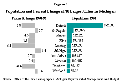
A recent trend in Michigan is the movement of people out of the city, into nearby suburbs
or rural areas, as the graphs below illustrate.


Parts of the text above have been paraphrased from a paper by R.H. Maybee originally published in the Michigan Academy of Science, Arts and Letters.
This material has been compiled for educational use only, and may not be reproduced without permission. One copy may be printed for personal use. Please contact Randall Schaetzl (soils@msu.edu) for more information or permissions.