The first mineral boom in the United States occurred
in 1843 when people from all over the continent began to chase the copper,
silver and iron of Michigan’s upper peninsula. These mines were in commercial
operation for more than a hundred years.
Michigan has produced over 14 billion pounds of copper
since mining began in 1844. Silver is often extracted along with the
copper deposits. The copper mined in Michigan help fuel the industrial
revolution that occurred in the US, because copper products were needed
by the growing nation. All mining of native metallic copper ceased
in the UP in 1969. Currently, Arizona leads the nation in copper production.
Michigan’s copper deposits were remarkable for their quality
and purity. Bands of native copper were contained in outcrops 2 to 8
miles wide and of varying depth. The surface deposits first attracted
the notice of Native Americans who dug out the easily accessible chunks
and fashioned copper tools and adornments from them. The British and
French saw the indigenous pieces but did little to exploit the resource.
Michigan’s unique contribution to archeology is found
in the ancient copper mines of the Lake Superior region. The presence
of copper in the rocks of the Keweenaw Peninsula has been known for centuries.
Copper artifacts show that long before Europeans arrived, native Americans
throughout the upper midwest used the metal for making a variety of ornaments,
tools, utensils, and weapons. Much of the copper used by the Native American
was "drift copper" — removed from the rocks by the glaciers and dropped
randomly in the glacial debris. The Indians were made aware of
the existence of the metal by masses of float copper carried south by the
glaciers and left lying on the surface. Sometime in the remote past,
an unknown tribe began to mine the native copper in the Upper Peninsula.
They dug pits in the ground and separated the copper from the stone by
hammering, by the use of wedges, and, possibly, by the use of heat. Thousands
of hammers have been found in and about the old pits. Copper from these mines
was widely distributed throughout the country, and it is probable that
numerous tribes made summer pilgrimages to the Upper Peninsula to get
supplies of the precious metal.
Copper jewelry and amulets worn by
the Indians excited the interest of the early white explorers. They learned
the Indians had not mined the copper but had found it scattered on the
surface west of Pictured Rocks. Explorers from the time of the Jesuits
on have searched without success for the "mother lode." Although
the French explorers were told of the copper deposits by the Chippewa
Indians in the early 17th century, no mining was attempted until late in
the 18th century, and none of the French mining ventures were successful.
In the early 19th century, settlers moving westward
from the eastern United States bypassed the UP because of its reputation
as an inhospitable wilderness. However, favorable attention was
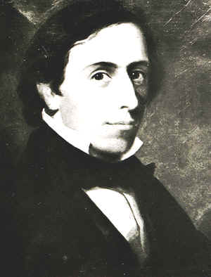
drawn to the region by Douglass Houghton’s (images below) 1841 geological
report describing the presence of copper on the Keweenaw Peninsula. Douglass
Houghton was Michigan's first state geologist.
Source:
www.detroitsalt.com
| Houghton's untimely death
On 14 May 1846, the Wisconsin steamed into Detroit’s harbor. Its flags hung at half-mast. The remains of Douglass Houghton – Michigan’s first state geologist, a mayor of Detroit, a physician and a pioneer in the development of the Upper Peninsula – were being brought home. Houghton had drowned near Eagle Harbor on the night of 13 October 1845 while making a survey of mineral lands in the Upper Peninsula. He was 36 years old. On 15 May 1846 a throng of mourners, including the entire Michigan House of Representatives, attended Houghton’s funeral. Later, Bela Hubbard, assistant state geologist from 1837 to 1841, would remember, "The peculiar characteristics of one not easily forgotten - his diminutive stature - his keen blue eye - his quick active motions - the strong sense and energy of his words when dealing with matters of science and his indomitable perseverance in carrying out his designs." |
The first copper mine opened in 1771, and its owner, Alexander Henry,
sent the massive Ontonagon Boulder--of pure native copper--to Detroit
as evidence of the region’s richness. But speculative activity did not
begin in earnest until 1841, hastened by the favorable reports of the
first state geologist, Douglas Houghton. These reports, combined with
publicity given the Ontonagon Boulder, sparked the first mineral rush in
the nation, predating by several years the more famous California gold
rush. Between 1843 and 1846, thousands of prospectors arrived from the
East with the hope of "striking it rich."
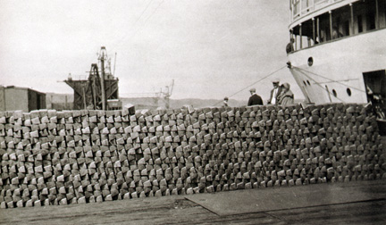
These events brought a rush of copper-seeking prospectors
into the Upper Peninsula in the early 1840s. Copper mining has
been almost continuous in the Keweenaw Peninsula area for the 150 years
since then. During that time over 12 billion pounds of native copper
have been mined. The image below shows pure copper ingots, awaiting
shipment.
Source: unknown
Source: Atlas of Michigan, ed. Lawrence M. Sommers, 1977.
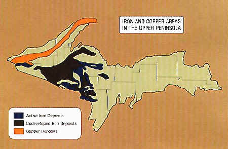
Iron and copper are the two most economically important minerals
in Michigan. Michigan produced 5,385,849 tons of copper
between the beginning of commercial operations in 1845 and 1969 when
several companies ended operations because of labor troubles.
Both these deposits have formed in Precambrian rocks (older
than 600 Ma [million years]), but by two very different mechanisms.
In order to understand the formation mechanisms, and why these minerals
occur where they do, we must first know the general geologic "story"
of the western UP.
Source: Unknown
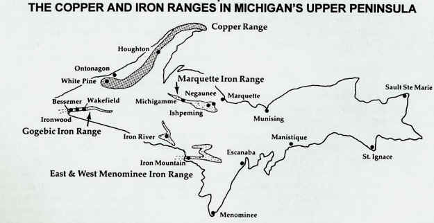
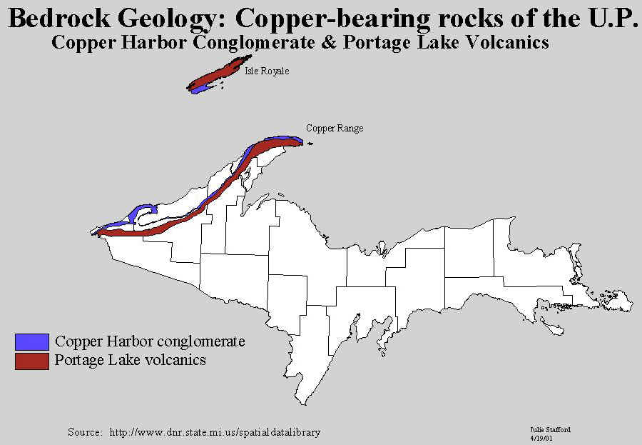
The state’s copper deposits extend in a
narrow band from the Michigan-Wisconsin border to the tip of the Keweenaw
Peninsula and out into Lake Superior. The copper-bearing rocks are late
Precambrian and mostly volcanic (basaltic lava flows) and sedimentary
in origin. Into the lava flows of Keweenaw, Houghton, and Ontonagon counties
percolating hot waters rising from great depths brought copper and silver
in solution. As it cooled, the waters filled the fissures and the gas
cavities (amygdules) of the lavas (trap rocks) with pure copper and silver,
making the greatest deposit of native copper in the world. Copper was
also deposited in the cracks in the Copper Harbor conglomerate. Many
beautiful minerals, as yet of no economic importance, are also found
associated with the copper.
Source: Unknown
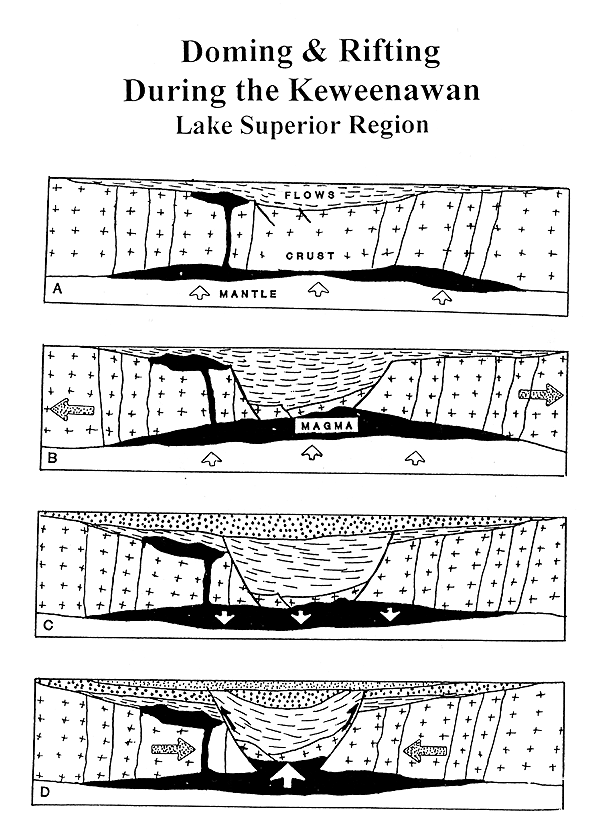
The sequence of diagrams above illustrate the events that occurred in the Lake Superior region, during Keweenawan time. They resulted in the formation of the Lake Superior syncline.
A. The crust cracks, and molten rock wells up from great depth, through
these cracks (joints). Lava flows cover the surface.
B. Large parts of the crust subside and form a graben. This subsidence
is thought to have occurred due to crustal extension, or thinning, as
it pulled apart. Some of the subsidence may have occurred due to the
tremendous weight of the lava (up to 12 miles in thickness!) that was
now at the surface, and within the graben.
C. Crustal extension and volcanic activity end. Sedimentation begins
within the now-sinking graben.
D. Compressional forces, pushing together from the east and west, squeeze
and fold the graben, and the lavas and sediments within, into a syncline.
Reverse faults occur on each side of the syncline as the rocks slide
upward, past each other. Sedimentation of sand and gravel (later these
will become sandstones and conglomerates) continues within the Lake Superior
syncline.
Source: Unknown
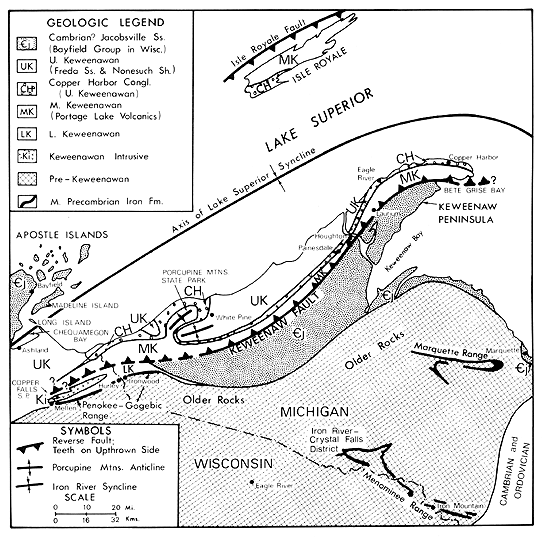
The location of the axis of the Lake Superior syncline is shown below. The syncline formed as the tremendous weight of the lavas caused the crust of sink and fold in on itself, further facilitating even more lava deposition within the syncline, or rift.
Source: Unknown
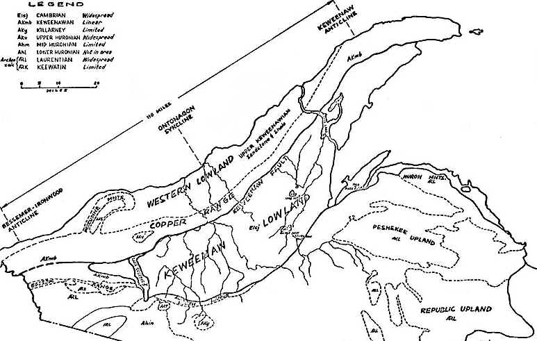
The map above shows the major geologic structures and physiographic regions of the western UP.
Source: Unknown
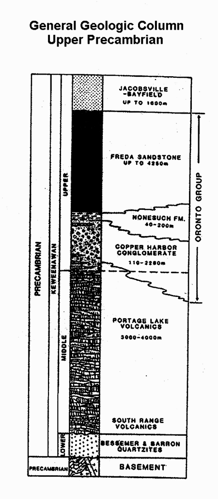
The generalized geologic column of the western UP provides us with
many clues about what was happening in this region during Keweenawan
time. The basement rocks, including the quartzites, are the eroded
remains of the Penokee Range.
On top of them were deposited many thousands of feet
of lavas, which poured out of fissures in the crust as it was rifting,
or spreading apart. These rocks are called the Portage Lake volcanics.
The image below, from the Copper Country, shows the polygonal cracking
that is so common on hardened lava flows.
Above them are sediments laid down after the volcanism
stopped. These sediments, now turned into rocks, were laid down
in the rift, by rivers, as fans of sediment coming off the uplands on
either side. Today, the Copper Harbor Conglomerate is known for
its range in sediment sizes--from silt to sand and lots of gravel too.
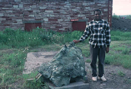
It is one of the main sources of copper ore. The image below shows
the Copper Harbor Conglomerate in a mine shaft. Note the old wooden
pillar in the foreground, the veins of greenish, oxidized copper on the
rock itself, and the large rocks and stones that make up the conglomerate.
Still higher in the column, the Nonesuch Shale is
represented as a silty and clayey deposit laid down in a lake in the
still-low-lying rift. The rocks even retain mud cracks--sure evidence
that the sediments were laid down in an intermittent water body.
The Freda and Jacobsville Sandstones have similar origins: they too were
laid down by rivers in the rift zone. However, for some reason the
rivers that carried the sediment were now carrying mostly sand, rather
than silt (as in the Nonesuch) and gravel/sand mixtures (as in the Cooper
Harbor).
In summary, the ore deposits of the Michigan Copper District are
of two basic types that differ in mineralogy, host rock type, and possibly
in origin. Furthermore, they are separated from one another both geographically
and stratigraphically.
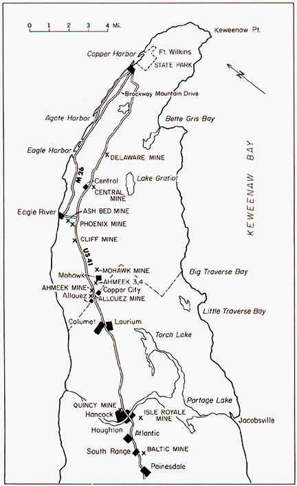
1. Deposits of native copper occur in the tops of
basaltic lava flows and in conglomerates interbedded with the basalts
in the Portage Lake Lava series of rocks. More than 96% of the native-copper
production has come from an area 45 km long, extending from southwest
of Painesdale to east of Mohawk. Over 11 billion pounds of metallic copper
have been recovered from these native-copper deposits. When this
type of copper occurs in large "chunks" or masses, it is referred to as
"Mass Copper" (see image below).
Source: Photograph by Randy Schaetzl, Professor of Geography - Michigan
State University
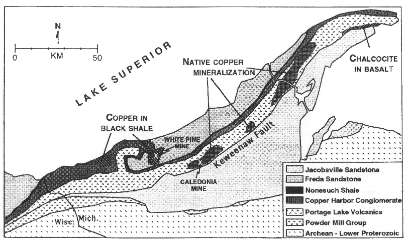
2. Deposits of copper sulfides (mainly chalcocite)
with smaller amounts of native copper occur in the lower 6 meters of
the Nonesuch Shale, which lies just above the Copper Harbor Conglomerate.
Minor amounts of copper minerals are found along this contact over a
distance of 200 km, but important deposits occur only in the Iron River
syncline at White Pine (the White Pine mine is still operating today)
and in the Presque Isle syncline on the west side of the Porcupine Mountains.
Over a billion pounds of copper have been recovered from the White Pine
copper deposit.
Source: Unknown
Native Copper Deposits. Michigan’s native-copper deposits are found almost exclusively in the Portage Lake Lavas. The lava "series" consists of over 200 lava flows with 20 interbedded conglomerates, sandstone and shale. The rocks strike parallel to the length of the Keweenaw Peninsula and dip to the northwest beneath Lake Superior. Some lava flows have been traced for 65 km along the surface.
Source: Uknown
The main ore deposits are widespread, thin, blanket-like
bodies (as are the lavas) found both in the amygdaloidal "bubbles" in
the tops of the lava flows, and in some of the intervening conglomerates.
Note the green, copper-rock vesicles in the ore shown below--there vesicles
were originally bubbles in the lava that have been filled with copper.
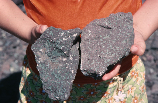
Source: Photograph by Randy Schaetzl, Professor of Geography - Michigan
State University
Commercial ore deposits are present at only about a dozen levels in
the Portage Lake Lavas.
The copper is believed to have been deposited from
hot water solutions rising from great depth along permeable layers in
the rock. Because the layers are (and presumably were at the time of
ore deposition) tilted down beneath Lake Superior, the solutions evidently
rose along the porous tops of lava flows and up through the interbedded
conglomerates. The copper carried in solution in the water was deposited
in cavities and pore spaces in the rocks due to changes in chemistry
and/or cooling of the fluids. Assuming that the solutions were widely
dispersed in the rocks, barriers to circulation caused more copper-bearing
fluids to pass through certain areas, which probably resulted in greater
accumulation of copper at these sites.
For a continuation of this page (part II of the "copper story"), click
here.
Some of the images on this page were taken from an issue of Michigan History magazine, and some were donated by Nate Verhanovitz, a mechanical engineering grad. student at MSU.
This material has been compiled for educational use only, and may not be reproduced without permission. One copy may be printed for personal use. Please contact Randall Schaetzl (soils@msu.edu) for more information or permissions.