SOILS
Soils are formed through a very complex process involving the nature of the parent
bedrock, climate, animals, vegetation, slope of the landform, and length of time the soil
has been in existence. Most of Michigan’s soils were developed from glacial sediments
deposited during the Ice Age. As the huge ice sheets moved southward over Michigan, they
picked up, eroded, and deposited rocks, sand, gravel, and silt. When the ice receded the
material collected in and underneath the ice sheets was left behind. Since then the
surface layers have been changed by the action of water, ice, wind, plants, animals, and
people. Thus, there are a great variety of soils, and in Michigan, soil characteristics
may differ dramatically from region to region, from field to field, or even within a
single field.
Soils are characterized by the differences in the various layers
(horizons). In natural settings, the mineral soil is overlain by the O (organic)
soil horizon, which is made up of decaying leaves, twigs, etc. (see below).
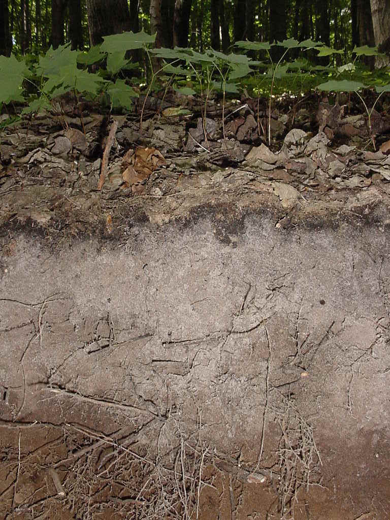
The topmost mineral horizon is called the A horizon and contains the partially
decomposed vegetable matter called humus, which helps to hold moisture and provide food
for plants to grow. In forest soils, the dark A horizon is underlain by a light-colored E
horizon, from which various amounts of clay, Fe and Al have been removed by infiltrating
water. The B horizon (below the E and A) is the zone that accumulates these
compounds. It is often brown in color.
The soils of Michigan vary greatly. Sandy soils are dominant in the
western and northern portions of the Lower Peninsula; clays and loams, in the southern
Lower Peninsula. The size of particles, or texture, varies in different kinds of soil.
Soils with a loam texture have a combination of soil particle sizes; there are sandy
loams, silty loams, loamy sand, and clay loams.
Loam soils are best for plant growth because sand, silt, and clay
together provide desirable characteristics. First, the different-sized particles leave
spaces in the soil for air and water to flow and roots to penetrate. The roots feed on the
minerals in the suspended water. Deep sands do not hold moisture well and are often
infertile. Clays hold moisture better than sands and may be more fertile, but they tend to
swell when they get wet, which may limit the movement of water and roots. Clays crack when
they dry and the clods become very hard and difficult to manage (for humans as well as
plants!). A desirable soil is a loam with enough sand to drain well yet with enough clay
and silt to hold to hold moisture. Silt-sized grains also contain nutrients and help make
a soil workable.
Some soils (Histosols) contain a large
amount of partially decayed vegetation (humus) and are called peat or muck. They are often
used for growing vegetables because of their high fertility. Thus, the distribution of
various kinds of soils in Michigan relates closely to the various types of crops grown and
how productive the agriculture is.
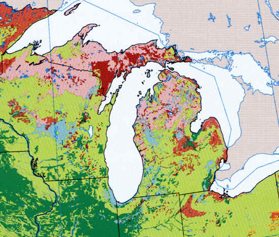
Soil maps can be created, and the soils of a region examined, along a number of
different scales and with differing degrees of accuracy and complexity. The map
below shows the soils of the western Great Lakes region at a very general level, in fact
at the broadest and most generalized level: soil orders (of which there are only 12 in the
world). The six major soil orders in Michigan each have their own web page (use the
"back" key to get to the list).
![]()

![]()
![]()
The soil information used for the three soil maps below, in this section of the GEO
333 web page, was Natural Resource Conservation Service 1994 STATSGO data. STATSGO was
compiled at 1:250,000 and designed to be used primarily for regional, multistate, State,
and river basin resource planning, management and monitoring.
(Web source: project..ftw.nrcs.usda.gov/stat_data.html;
Metadata: project..ftw.nrcs.usda.gov/metadata/mi.html)
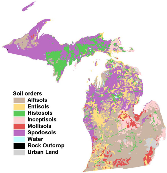
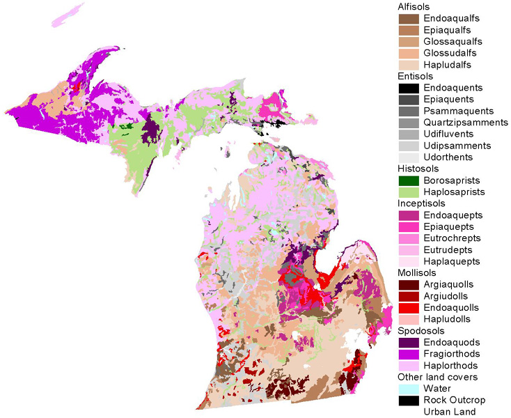
A more accurate map of the major soil orders in Michigan is shown below. Note how
Spodosols dominate the UP and northern lower peninsula, except of clayey landscapes (here
you'd find Alfisols) and the wettest swamps (here you'd find Histosols), and how Alfisols
dominate the southern lower peninsula.
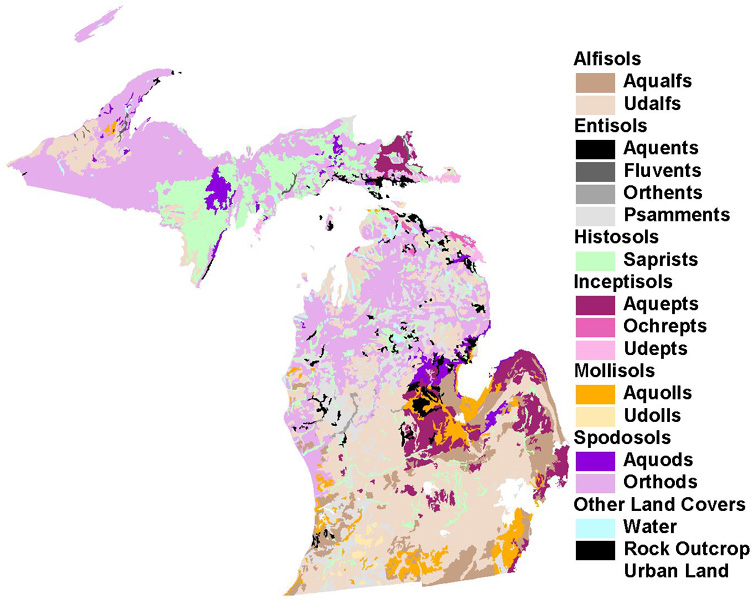
The two maps below show even more detail, breaking the soil orders down into suborders and
then Great Groups.
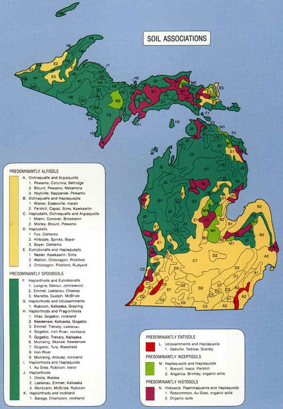
Another way to look at soils is by their major associations. A soil association represents several types of soil that commonly are found together.
But what about soils in neighboring areas and states? The map below provides some
information along these lines.
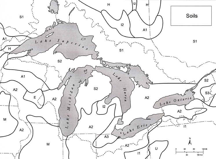
KEY:
S: Spodosols
E: Entisols
M: Mollisols
A: Alfisols
U: Ultisols
H: Histosols
Parts of the text on this page have been modified from L.M. Sommers' book entitled, "Michigan: A Geography".
This material has been compiled for educational use only, and may not be reproduced without permission. One copy may be printed for personal use. Please contact Randall Schaetzl (soils@msu.edu) for more information or permissions.