PHYSIOGRAPHIC REGIONS AND UNIQUE PLACES
A physiographic region is one that has similar landforms and similar evolutionary history.
For example, the Alps might be one kind of physiographic region, as may be the
North Slope of Alaska, or the Mojave Desert. Michigan has many physiogrphic regions,
each with some sort of internal commonality.
Because one can define such regions differently, there are various
types of maps of these types of regions. The most simple involves a simple
description of the "lay of the land", such as high hills, mountains, plains,
etc. The two maps below show such classifications for Michigan. Note that the
map does not differentiate based on HOW the landscape were FORMED, only how they APPEAR
today.
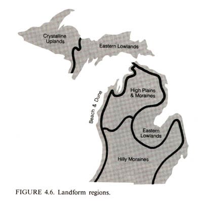
The sections below describe, in general, some of these major physiographic regions.
Hilly Moraines dominate much of the interior part of the
lower half of the Lower Peninsula. This region is largely made up of a series of looping
end moraines from10 to 25 miles apart. The moraines are low ridges, and the area between
them is often much flatter and is generally composed for outwash
plains or ground moraine. There are two interlobate moraine areas in this part of Michigan: one extends
from the Indiana border north toward the thumb area of Michigan and includes the Waterloo
Recreation Area; the other is found north of Kalamazoo and Battle Creek, and it extends
east of Grand Rapids and north toward the city Big Rapids in Mecosta County. The
region as a whole can be characterized as gently rolling to hilly with a considerable
amount of relatively level topography and many lakes and poorly drained land. For
agriculture and industry, this is one of the best developed parts of the state. On the
northern edge of the region, a high sandy plain marks the dividing line between the
densely populated portions of the Lower Peninsula and the more sparsely populated areas to
the north.
The Beaches and Dunes that bordering Lake Michigan are among
the most beautiful in the Great Lakes region. They vary from being low and forest-covered
to being high and bare, like the Sleeping Bear Dunes in the northwestern part of the Lower
Peninsula. Many of the dunes are glacial ridges that have been built up by blowing sand
from the beaches of Lake Michigan. The prevailing westerly winds have piled the sand up in
mounds of various heights, and some of them, like the Sleeping Bear Dunes and Silver Lake
Dunes, are still moving inland. But generally speaking, the forest or dune-grass cover
keeps the dunes stable and makes them more permanent. Because of the natural beauty and
the quality of the sand, beaches, and water, this area is important for recreational
development. The dune sand is also being mined as industrial sand in several places--a
source of increasing worry for environmentalists and other citizens. The beaches are
outstanding: The fine, white sand extends along virtually the entire Lake Michigan shore.
The actual width of the recreational beach varies from time to time depending upon the
level of Lake Michigan and the kind of erosion or deposition that is taking place. When
the lake is high or there are heavy storms, serious erosion takes place, and the waves eat
away large quantities of sand. Erosion has been cyclical along the coast over the years,
so the width of beach and dune area varies with a rising or falling lake level.
High Plains and Moraines Most of the area north of the Muskegon-Saginaw Bay line is dominated by the region called the high sand plains. This glacial landscape differs from the areas to the south in that the concentrations of sandy soils are much higher, the moraines are more massive and rolling, and the general elevation is higher. Many of these hills are meccas for winter ski enthusiasts, and for the summer (golfing) tourist, a large number of inland lakes dot the landscape. The combination of varied topography, limited farmland, large areas of forest and lake country, and clear trout streams form the basis of a region that is highly utilized by the large urban population of southern Michigan for summer as well as for winter recreation. Some farming does take place, but other activities such as forestry and tourism are much more important than in the southern Lower Peninsula. Excellent highways have made this area easily accessible to the urban south.
Eastern Lower Peninsula Lowlands Very flat topography is
found near the coast in the southeastern part of the state, and it extends north to the
Saginaw Bay area and along Lake Huron to the tip of the Lower Peninsula. This land was
under large glacial lakes, and then as the land rose and the lakes lowered, the rather
extensive, flat, fertile plains, were brought into existence. The flatness of the
topography has allowed cities to develop in a sprawling fashion as the only major obstacle
to urbanization in this area has been the great amount of poorly drained land.
Eastern Upper Peninsula Lowlands The eastern half
of the Upper Peninsula is a relatively flat, largely lacustrine, lowland. In places, the
surface material is very thin; and on some of the eastern islands, such as Drummond
Island, the sedimentary bedrock is visible. Glacial hills are scattered throughout the
areas, and the Niagara Escarpment (an outcropping of resistant Niagara limestone) is found
along the southern flank of the region. Large portions of this area are covered by state
and national forests, wildlife refuges, lakes, ponds, and poorly drained land.
Agricultural land is limited, but a few places--such as the Munising area--are quite well
developed considering the northerly latitude and the relatively short growing season.
A large number of short streams flow south into Lake Michigan or north into Lake
Superior. Most are excellent trout streams. The striking Tahquamenon Falls on the
Tahquamenon River is a major tourist attraction. Along Lake Superior shore, there are two
additional outstanding features: Pictured Rocks National Lakeshore, with its beautifully
sculptured sedimentary rocks in the vicinity of Munising, and the high sand dunes near
Grand Marais to the east. The St. Marys River, which forms the boundary between Canada and
the United States in this area, has several rapids and falls that have been eliminated by
a series of locks that allow vessels to go between Lake Huron and Lake Superior. Two
cities, each called Sault Ste. Marie, have developed on both sides of the international
border in the vicinity of these important locks.
Crystalline Uplands The western Upper Peninsula
is one of the most scenic regions in Michigan. Old resistant mountain cores, especially
the Porcupine and Huron mountains, and other resistant, igneous rock areas are part of an
old Precambrian Shield that extends north into Canada. The rocks were sculpted into
various forms by the continental glaciation, and the soil is generally thin and infertile.
Glacial materials often form ridges on top of the igneous rocks. The highest point in the
state - Mount Arvon 1979 feet above sea level--is found in the Huron Mountains. The
Gogebic Range also extends into this part of Michigan, as do several other highlands that
contain considerable iron ore. Copper is mined on the Keweenaw Peninsula, and for a
long time this mineral was an important resource base for many of the urban developments
there. When copper mining declined, settlements were abandoned as people moved on to areas
where the economy was more reliable. Today, a few crumbling ghost towns remind one of the
prosperous copper era. Today, though, the extraction of iron ore is the most important
mining activity in the area, and towns such as Ishpeming and Negaunee near Marquette
largely owe their existence to this activity. Forests, both national and state,
cover much of the western Upper Peninsula, and forestry is a leading activity. The
forested hilly land, often dotted with lakes, is attractive to tourists, so the recreation
industry is growing in importance here as well. The hilly topography and the cold, snowy
weather are also conducive to winter sports. Agriculture is relatively limited in
the western Upper Peninsula because of topography, elevation, and the shortness of the
growing season. Potatoes are a major crop in this region, and the rest of the agricultural
activity centers largely around dairying. Forestry is important throughout the area, and
there is also some commercial fishing of white fish and lake trout along Lake Superior.
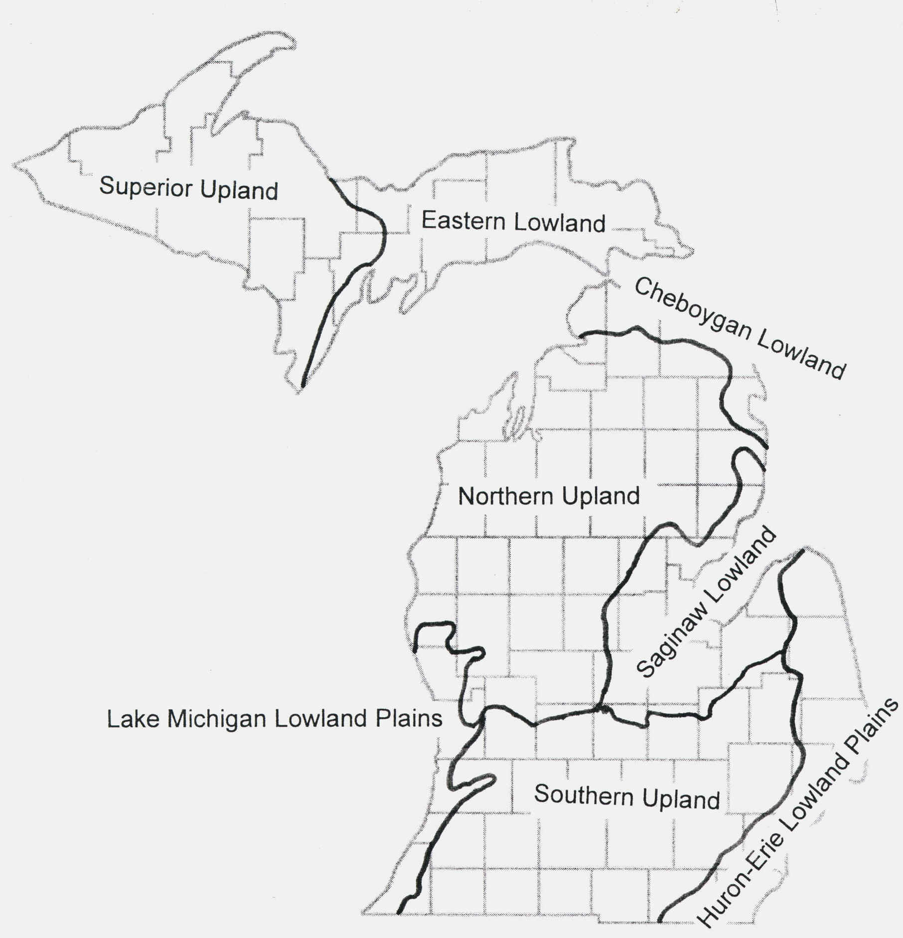
Another way to categorize and separate the major physiographic regions of the state is
presented below:
The map below splits the state into still more physiographic regions--that is, it provides
a more detailed breakdown of the physiography of Michigan.
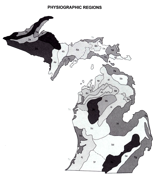
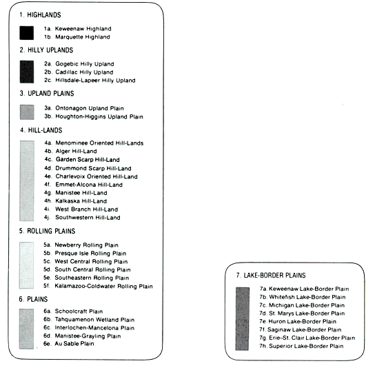
LEGEND:
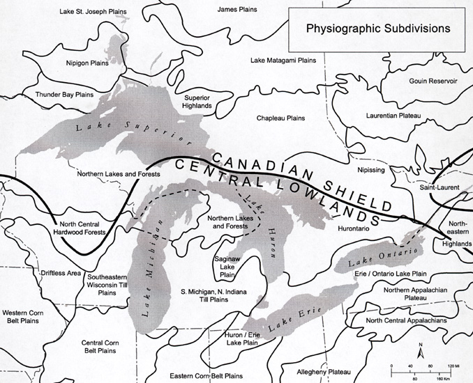
The map below, although it is in part "sprinkled" with vegetative
classifications, provides a more detailed look at some of the physiographic regions
outside of Michigan---within the Great Lakes region proper. Still, no genetic
subdivisions are given.
Parts of the text on this page have been modified from L.M. Sommers' book entitled, "Michigan: A Geography".
This material has been compiled for educational use only, and may not be reproduced without permission. One copy may be printed for personal use. Please contact Randall Schaetzl (soils@msu.edu) for more information or permissions.