LAKE ALGONQUIN SHORELINES ON MACKINAC ISLAND
During the long time that Lake Algonquin stood at
its several levels, waves were at work making cliffs and cutting promontories into the
shores of its islands---including Mackinac Island. The waves cut chimney rocks,
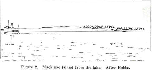
built beaches, and cut terraces into the sides of the island. As one approaches Mackinac
Island by boat the island seems to rise in gigantic steps from the lake shore to Ft.
Holmes at the summit (see image and drawing below). The stair-step
"treads" are the wave-cut terraces (the old beaches), whereas the
"risers" are the wave-cut cliffs of the ancient shores. The shore features
made by the ancient lakes, now high and dry above the level of the modern lake, are the
most striking features of the island.
ALGONQUIN LEVELS
Lake Algonquin had at least three levels--that is it had three (or
more) water planes that remianed at essentially the same elevation for long periods of
time and cut well-defined notches on its islands and shorelines.
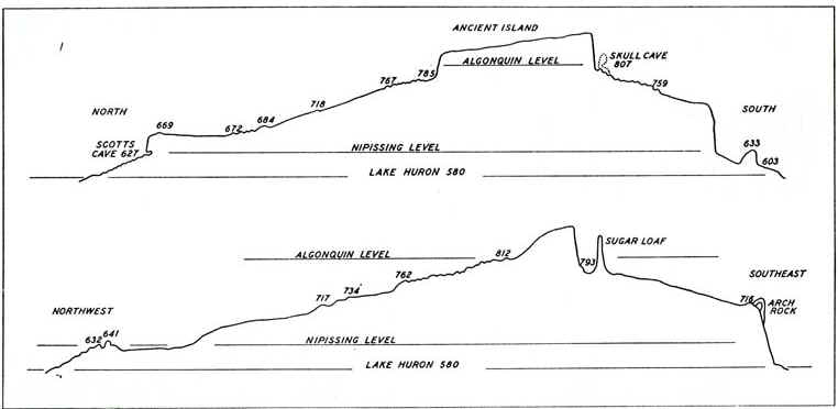
HIGHEST (MAIN) ALGONQUIN
The high hill on Mackinac Island, which stood as an island in even the
highest or Main phase of the lake, has been referred to occasionally as "the Ancient
Island". It is little more than half a mile long and almost a quarter of a mile wide.
It is highest at the southeast end, the strategic eminence of Fort Holmes. In fact the
highest natural point (elevation 891 feet) is at the very tip of the Ancient Island which
drops away abruptly in a wave-cut precipice. The top of the island near the north end is
60 feet lower. Algonquin sea cliffs skirt the Ancient Island almost completely, and the
long northeast face is one continuous cliff for almost a kilometer. The south side also is
cliff, as well as the southwest side as far as Fort Holmes Road. The north tip is
surrounded by cliffs which reach south for one quarter mile along the west side.
LOWER ALGONQUIN BEACHES
Below the upper Algonquin beach is a zone or interval where no beaches
were formed because the lake fell with comparative rapidity due to drainage at new (lower)
outlets. However, the lake eventually stabilized at two lower levels, and cut two
small beaches on the island. These beaches are small and not easily seen from a
distnace, but they are, nonetheless, present. They are given the names
"Battlefield" and "Fort Brady" beaches, with the Battlefield beach
being the higher of the two (at 718 feet).
The type Battlefield beach is a conspicuous ridge in the open land east
and west of British Landing Road and stands six feet above the swale. Its elevation in
this stretch varies between 718 and 716 feet, but is nearly everywhere 717 feet. Wave cut
bluffs border the north side of the hill east of the beach and from the hill another ridge
at similar elevation continues to the northeast. The beach is weakly developed at a few
spots along the most northerly part of Leslie Avenue. Bordering the front of the beach on
the golf course are the few weak shoreline marks at lower levels. A sandy ridge just east
of the club house, a foot or so below the principal Battlefield ridge marks the landward
edge of a little lagoon closed off by it.
Since the Battlefield stage of the lake was but a temporary halt in the
decline of lake level as ice barriers were giving way, its mark on the land is less
imposing than the records made during the highest Algonquin or Nispissing stages. The
Battlefield shoreline is not continuous around the island. However, a number of fragments
of it may be identified where gravelly ridges are found at accordant altitudes.
To understand the method of correlating shorelines by elevations it must be remembered that all but the most recent shorelines have been tilted up to the north-northeast, along what is called the "tiltline". The tilt is a fact well established by detailed measurements over the whole lakes region.
This material has been compiled for educational use only, and may not be reproduced without permission. One copy may be printed for personal use. Please contact Randall Schaetzl (soils@msu.edu) for more information or permissions.