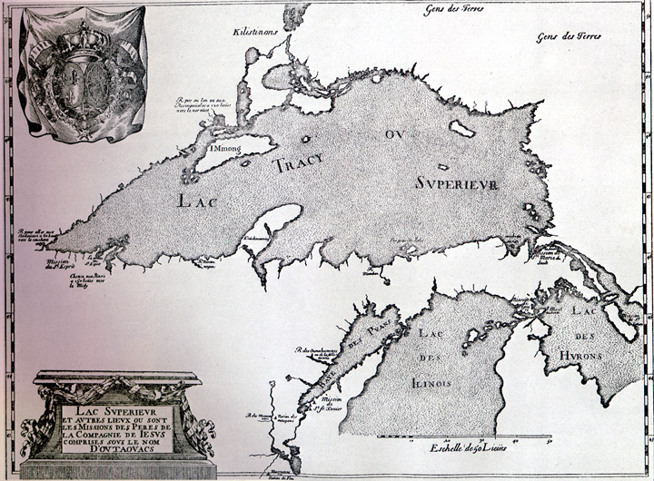
The name "Lake Superior", as best as historians can tell, comes from an account of a French missionary who, in 1648, remarked that the falls at Sault Ste. Marie was the place where a "superior lake" discharges into the "Fresh Water Sea" (Lake Huron).
Not only is Lake Superior the largest of the Great Lakes, it also has the largest surface area of any freshwater lake in the world. It contains almost 3,000 cubic miles of water, an amount that could fill all the other Great Lakes plus three additional Lake Eries. With an average depth approaching 500 feet, Superior also is the coldest and deepest (1,332 feet) of the Great Lakes. The lake stretches approximately 350 miles from west to east, and 160 miles north to south, with a shoreline almost 2,800 miles long. The drainage basin, totaling 49,300 square miles, encompasses parts of Michigan, Minnesota, Wisconsin and Ontario. Most of the Superior basin is sparsely populated, and heavily forested, with little agriculture because of a cool climate and poor soils.
Lake Superior receives the least amount of surface runoff, in relation to its volume, of
all five Great Lakes. This is because most of its watershed is forested, and its watershed
is small, when compared to its water surface area. No major tributaries enter the lake
from the south. On the Canada side, a diversion of water from the Hudson Bay watershed
provides an additional input of water to the basin.
FLUCTUATIONS OF LAKE SUPERIOR WATER LEVEL
Lake Superior is the largest of the Great Lakes, with a total area of over 82,000 km2
. Waves on exposed shores, where fetches may exceed 500 km, can reach 6 m. Thunder
Bay is much more sheltered: maximum fetch is no more than 50 km and waves rarely exceed 2
m in height. The water level of Lake Superior fluctuates on both long-term and seasonal
bases. Since monitoring began in 1860, the lowest mean annual level of Lake Superior was
recorded in 1925-26 at 182.8 m. The other extreme occurred in 1985-86, when new monthly
record highs were set for 12 consecutive months, at levels exceeding 183.4 m. Long-term
fluctuations appear to have an irregular cycle: high water levels were experienced in
1915-16, 1950-52, 1972-74 and 1985-86. Seasonal regimes are more predictable: the lake
normally fluctuates about 30 cm, being lowest just before the snow melts in spring, and
highest in September. More spectacular changes in level result from short-term (hourly)
oscillations of the lake surface induced primarily by winds and differential barometric
pressures. Wind set-up and seiche or barometric surface tilt may raise or lower the lake
level along a given shore by as much as 1 m within a period of a few hours.
The principal causes of long-term fluctuations in the level of
Lake Superior (and the other Great Lakes) are natural, and can be explained in terms of
the lake’s water budget. When inputs of precipitation, ground water, surface runoff
and streamflow exceed the outputs of evaporation and outflow from the lake for a
significant period of time, the lake level rises. The most important variables are
precipitation and evaporation. An extended period of below-normal precipitation in the
1960’s was characterized by low lake levels. In contrast, precipitation was above
normal for 13 of the 16 years between 1960 and 1985, resulting in high water levels in all
five Great Lakes. On a long-term basis, Lake Superior basin precipitation and water levels
have gradually increased since 1900. In addition, the Great Lakes have been in a cool air
temperature regime since 1960, resulting in lower evaporation and higher runoff rates than
would occur with average temperatures.
Lake levels are also affected by human regulation systems.
Outflow is regulated through the locks at Sault Ste Marie by the International Joint
commission (IJC), while two diversion structures (Ogaki River and Long Lac) divert about
500 m3/s of streamflow from the Hudson Bay basin into Lake Superior. Working
under an agreement known as Plan 1977, the IJC strives to keep Lake Superior’s mean
level between 182.8 and 183.4 m, while balancing water levels between Lake Superior and
Lakes Michigan, Huron and Erie. However, the lake’s natural water balance overrides
the effects of human regulation systems. If the natural balance remains unchanged, then
the greatest effect human control of outflow could have on the level of Lake Superior is
less than 8 cm in six months.
FACTS
Length - 350 miles / 563 km.
Breadth - 160 miles / 257 km.
Ave. Depth - 483 ft. / 147 m.
Max. Depth - 1,332 ft. / 406 m.
Volume - 2,900 cubic miles / 12,100 cubic km.
Water Surface Area - 31,700 sq. miles / 82,100 sq. km.
Drainage Basin Area - 49,300 sq. miles / 127,700 sq. km.
Shoreline Length (including islands) - 2,726 miles / 4,385 km.
Elevation - 600 ft. / 183 m.
Outlet - St. Marys River to Lake Huron
Retention/Replacement Time - 191 years
Name - The first French explorers approaching the great inland sea by way of the Ottawa
River and Lake Huron referred to their discovery as le lac superieur. Properly translated,
the expression means "Upper Lake," that is, the lake above Lake Huron.
Kitchi-gummi, a Chippewa Indian translation, signifies Great-water or Great-lake. A Jesuit
name, Lac Tracy, was never officially adopted.
More facts about Lake Superior
Lake Superior is the largest of the Great Lakes in surface area and volume.
Lake Superior could contain all the other Great Lakes plus three more lakes the size of
Lake Erie.
Water flows into the lake from many small rivers and streams.
The Long Lac and Ogoki diversions in Canada channel water into Lake Superior that would
otherwise flow into Hudson Bay.
By order of the International Joint Commission, the lake's level, controlled by gates on
the St. Marys River at Sault Ste. Marie, may not exceed 602 ft (183 m) above sea level.
Each year a small percentage of the lake's water flows out through the St. Marys River,
and it takes almost two centuries for the water to be completely replaced (retention
time).
The Lake Superior drainage basin is rich in natural resources and scenic beauty.
It is sparsely populated and economically dependent on its natural resources, which
include metals, minerals, forests and recreation/tourism opportunities such as national
lakeshores and national/state/provincial parks.
It is particularly known for its clear, cold water and agate beaches.
Many shipwrecks in Lake Superior are now protected in bottomland preserves and accessible
to recreational divers.
In 1985, scientists using a submersible vessel descended for the first time to the deepest
part (-1,333 ft./-405 m) of Lake Superior near the Pictured Rocks National Lakeshore in
Michigan waters.
This material has been compiled for
educational use only, and may not be reproduced without permission. One
copy may be printed for personal use. Please contact Randall Schaetzl (soils@msu.edu)
for more information or permissions.