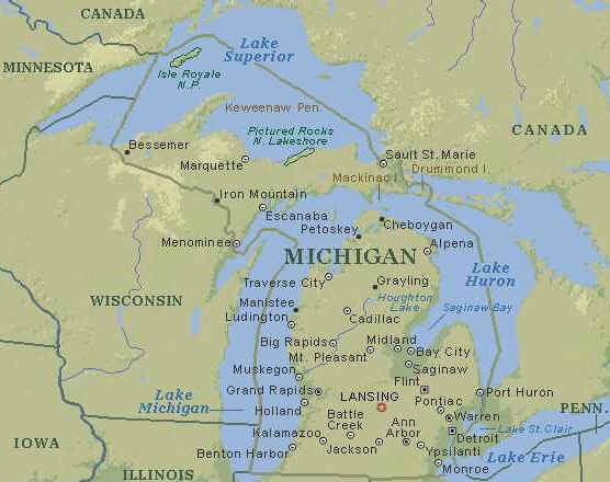
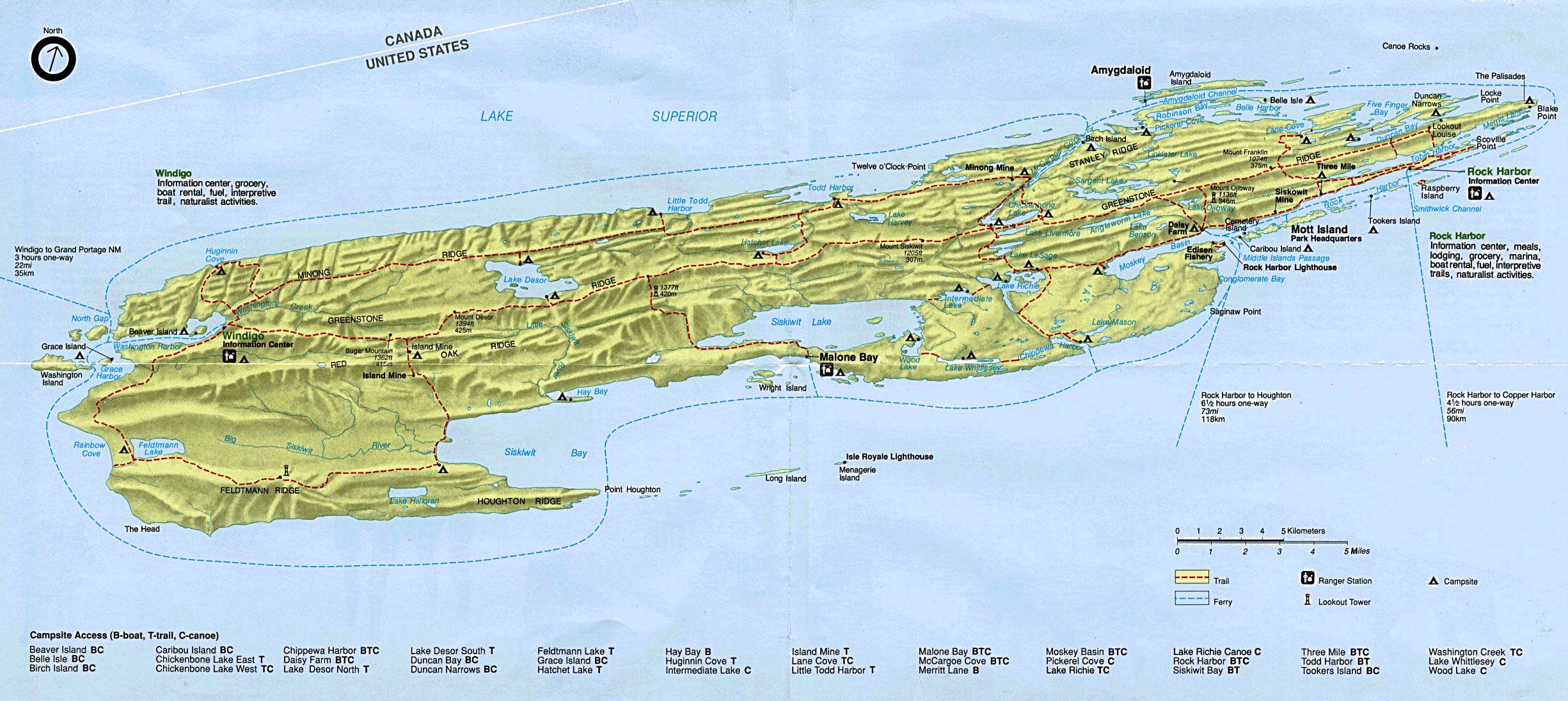
ISLE ROYALE
If someone had to guess what the largest island in Lake Superior was used for, most people
would probably say mining or lumbering, but chances are few would guess
"recreation". But, that is exactly what Isle Royale is used for; the entire
island is a National Park, and does not contain any paved roads. This means there is no
human disturbance on the island except for 165 miles of hiking trail, and one lodge. This
lets the wildlife of Isle Royale flourish. Such animals as moose, bald eagles, and even
gray wolves inhabit the island. As seen on the map the island itself is situated in Lake
Superior between the Keweenaw Peninsula and Ontario, Canada.
History
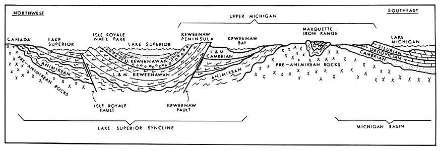
Isle Royale’s
geographical history begins about 1.2 billion years ago, during the early
Proterozoic Era, when a great rift opened in the earth’s crust. The rocks
produced in the Isle Royale area due to this earth-shattering event (such as
volcanic rocks, sandstones, and conglomerates) form the bedrock of today’s Isle
Royale National Park. The cycle of lava eruptions, and erosion (with later
glacial movements) combined to give Isle Royale its landscape of ridges and
valleys; glaciers overran the ancient lava flows, from the northeast to the
southwest, and resulted in the entire system of islands being composed of many
distinct parallel ridges. Today, this series of island-long, bedrock ridges, as
well as the valleys that run between ridges (which usually contain wet swamps or
beaver ponds) dominate Isle Royale’s landscape. These two topographical
features provide most of the primary impediments to cross-country travel, such
as marshlands, rocky ridges, shrubbery, and wind-fallen trees.
Around 11,000
years ago, 2 miles of ice lay on top of Isle Royale, pressing it down into the
earth and sculpting its topography. 10,000 years ago, the islands
began to appear from beneath glacial ice as the glaciers began their retreat and
the originally high lake levels dropped; this
process gave birth to hundreds of inland lakes, ponds and bogs.
The southwestern end of Isle Royale contains fewer inland lakes than the
northeastern end, while topography is a bit more rugged at the northeastern end,
where glacial sediments are spread thinner. The last major glaciation, the
Wisconsin, paused in its retreat and deposited several small linear moraines
there. Today, the main island is 45 miles long and nine miles wide at its
widest point; however, the whole National Park archipelago and its submerged
lands extending into Lake Superior encompass a total area of 850 square miles.The Treaty of 1783 specifically gave Isle Royale to the United States. It stated that the
water boundary should run "northward of the isles Royal and Phelipeaux." The
latter island first appeared on a map prepared by the cartographer Bellin in 1744. The
island does not exist, but it continued to appear on maps of Lake Superior for many years,
including the map used in the Paris peace talks, in 1783. Many writers and others,
including park rangers at Isle Royale National Park, have perpetuated the story that
Benjamin Franklin, knowing of the existence of copper deposits on Isle Royale, managed to
include the island within the United States because of that knowledge. This story, for the
most part, has now been disproved. Mitchell’s map shows both Isle Royale and the
mythical island of Phelipeaux centrally located in Lake Superior, which was, in the case
of Isle Royale, considerably to the south of where that island is actually located.
According to historians, the natural water "dividing line" that the negotiators
were attempting to describe in the Treaty of 1783 would run north of Isle Royale, which is
no doubt the reason the island was placed on the American side of the line, where it would
ultimately fall within the boundaries of the state of Michigan.
Prior to the official incorporation of Isle Royale into the United States, trappers frequented the island and found it to be quite the profitable venture, as it had a large beaver population ripe for the picking. With the end of the Seven Years War and their defeat at the hands of the British soldiers and colonists, the short-lived fur hegemony enjoyed by the French and Ojibwa fur-traders passed quickly to the British trading companies. Following the resolution of the Revolutionary War, the passage of the Northwest Ordinance displaced the British Hudson's Bay Company from the island and the American Fur Company quickly filled in the trading void. As the world fur market collapsed in the early 1800's (and beavers became nearly extinct in the northern regions), John Jacob Astor and his American Fur Company began to try other ways of making money from their holdings in the area. Several geological surveys were dispatched to catalog the mineral wealth of Isle Royale, and after the surveys of Douglas Houghton, a mining boom enveloped the entire Upper Peninsula of Michigan, which eventually spread to Isle Royale. Three separate periods of mining operations occurred throughout the 1800's, but the Siskowit Mining Company was the only group that extracted significant quantities of ore, taking 95 tons of refined copper ore during a six-year period that started in 1849.
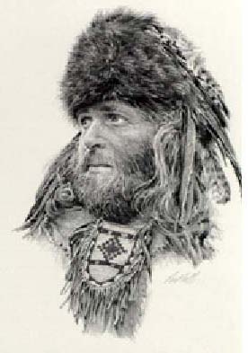
A fur trapper
Source: The Mills Pond Press Companies

Douglas Hamilton
In 1843, Isle Royale was officially acquired from the Ojibwa Indian tribe through one of the many Indian cessations of the time, but the basic idea of establishing a national park like Isle Royale did not come until March 3, 1931, when President Herbert Hoover authorized Congress to find a prime expanse of northern wooded wilderness and make efforts to conserve it. On April 3, 1940, Franklin D. Roosevelt officially established the Isle Royale National Park, which today is the least-visited National Park in the U.S. (outside of Alaska). Only about 15,000 people visit the island between mid-April and November. The park was added to the National Wilderness Preservation System in 1976, and over 98% of Isle Royale is now federally owned land that is open to public use and enjoyment. In 1981, the United Nations designated Isle Royale as an International Biosphere Reserve, giving it global scientific and educational significance. At present, Isle Royale National park consists of one large island (Isle Royale) surrounded by about 400 smaller islands. Isle Royale is located in the northwest section of Lake Superior, and is actually closer to Canada than to the United States (being only 15-18 miles from Canada and about 50 miles away from the U.S.).
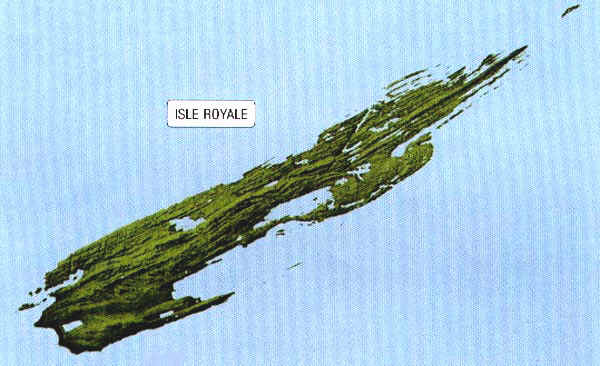
Although the island is actually much closer to Ontario, Isle Royale is a part of the
United States. The island wilderness was deemed a National Park in 1931, and today it
stands to be not only the smallest National Park, but also the only island National Park.
The island is 50 miles (80 km) off the tip of the Keweenaw Peninsula, 56 miles (90 km)
from Copper Harbor, but only 15 miles (24 km) from Ontario. Although the island is the
largest in Lake Superior, it is not really that immense. It measures 44 miles long (71 km)
and 8 miles wide (13 km). The total area for the entire island is 231,395 hectares, or
roughly 571, 790 square miles. Even though the island is not immense, there is enough land
here to let all the wildlife thrive.
All of these traits on the island were formed due to the scouring it
got from the glaciers. The glaciers also left deep coastal inlets as well as fjord-like
lakes around the island.
The scenery is not the main attraction though; the main attractions to
many are the animals. Animals such as moose, gray wolves, and bald eagles attract the most
attention. Both the gray wolf and the bald eagle have spent many years on the Endangered
Species List. Just recently the bald eagle was taken off of the list and put onto the
Threatened List.
Click here for full size image (374 kb)
Today, the Isle Royale National Park is generally open from mid-April until October 31st and closed to the public during other times of the year. Isle Royale is only accessible through boat or seaplane, and there are no roads anywhere on the island. Isle Royale has 165 miles of scenic hiking trails, as well as 36 campgrounds for backpackers and recreational boaters. Visitors have limited options as to how they wish to travel through the Park, and these transportation styles are back-packing and hiking across the land, or using personal boats or kayaks to traverse the island’s many streams and rivers. The National Park contains an abundant array of wildlife for visitors to spot, including wolves, moose, river otter, beaver, hare and fox, as many of these animals have come in search of areas better able to support them. Also, Lake Superior is an excellent source for sport fishing, and while the inland lakes are warmer than the icy waters of Lake Superior, “swimming” is often not a good idea due to rocky, weedy shorelines and leeches.
Source: David W. Miller
For visitors to Isle Royale National Park, there are plenty of opportunities available to enjoy the natural beauty, either on their own or with guidance from the Ranger services. The Ranger activity services provide many educational and enjoyable programs throughout the national park’s open period. For a link to the ranger activity/programs, click here.
In addition, guided excursions explore many panoramic areas of the national park, such as the Greenstone Ridge, some of the many reefs and pebble beaches, as well as historic lighthouses and shipwrecks (the lighthouses must not have been too effective, it seems), ancient copper mining sites, and plenty of panoramic spots to view the landscape and the wildlife. Activities include nature and historical walks, campfire talks, and scenic boat cruises to different parts of the island, including a historic lighthouse and a commercial fishery.
Commercial fishing has been one of the mainstay economic activities on the island throughout historic times, as some 80 percent of the national park is under the many shallow, warm-water ponds, streams, and rivers, as well as cold waters of Lake Superior. The major economic species were once the lake trout, whitefish, and herring. Sport fishing has now replaced commercial fishing, however, and the most sought after species are lake, brook, and rainbow trout and the yellow perch. Fishing is possible in many of the inland lakes, with the northern pike being the most prominent catch there, whereas in Lake Superior one can find lake trout and whitefish.
The Greenstone Ridge, the island’s backbone, is its highest and longest ridge; the ridge is named for the color of the underlying Greenstone Flow, which is a basalt flow that gets up to 800 feet thick and possesses a greenish hue; it is thought to be a portion of the largest lava flow on earth that once covered an area from Kansas all the way up into Canada. Running more than 40 miles along the ridge is the Greenstone Trail, which provides hikers with several locations for excellent views of the island to either side.
Greenstone Ridge
Source:
Doug Welker
The pebble beaches and reefs of Isle Royale National Park are not only notable because of their natural beauty, but also because they contain the Isle Royale Greenstone. The Isle Royale Greenstone, or chlorastrolite (“green star stone”), is a greenish, pea-sized stone that is uncommon outside of Isle Royale; in 1972, the Isle Royale Greenstone became Michigan’s official state gemstone.

Isle Royale Greenstone (MI state gemstone)
Source: Da Yooper
The historic mining sites show that prehistoric peoples, who came to mine the copper they found on the island and forage for fresh food, visited Isle Royale. They came to the island only in mild seasons, taking what resources they could, and leaving before winter. As early as 4,000 years ago, these people mined here, continuing for more than 1,000 years.
Other interesting and scenic places to visit while in the national park include Rock Harbor and the Rock Harbor Lighthouse, as well as Malone Bay. Rock Harbor is located on the northeastern edge of Isle Royale, and visitors can find Malone Bay in the central area of the southern edge of the island. Rock Harbor has many scenic, rocky shorelines, picturesque overlooks, secluded coves for picnicking, and boreal forests to hike through. The Rock Harbor Lighthouse is Isle Royale’s oldest, built in 1855 to guide the ships safely into the copper ports.
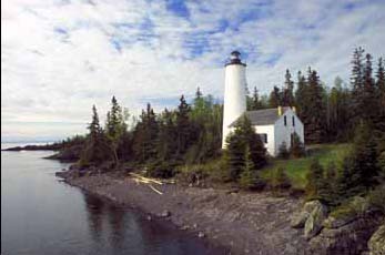
Rock Harbor Lighthouse
Source/Copyright: Steven Wayne Rotsch
The Isle Royale National Park is home to many different kinds of flora, including several species of trees, shrubs, and flowers, with many found in the island’s boggy marshlands. Even though Isle Royale is often touted as an "Island Wilderness,” at one point it was almost completely cleared of forestation and then settled by American frontiersmen and miners, which resulted in the elimination of over half of the island's original plant and animal species (such as woodland caribou). Copper miners in the 1800s burned virtually all of the forest down in an effort to reveal the bedrock of the island during searches for profitable mineral veins. Many of the oldest upland forests of any significance on Isle Royale are no older than 160 years, dating back to the first wave of extensive burning by miners in 1843. Boreal forests of white spruce, balsam fir, white birch, and aspen dominate most of the Isle Royale National Park, but there are some northern hardwood forests, containing yellow birch and sugar maple, found in the interior of the island. Northern white cedar dominates most boggy wetland forests. Isle Royale possesses many different floral species, including an abundance of bog plants, several species of plants more typically found along the northern coasts of Lake Superior, and around a dozen beautiful orchid species. A few examples of the island’s orchids and wildflowers are the purple fringed orchid, the calypso orchid, the swamp candle, and the bog laurel. Also, plenty of various kinds of edible wild berries can be found in August, including blueberries, raspberries, and thimbleberries.
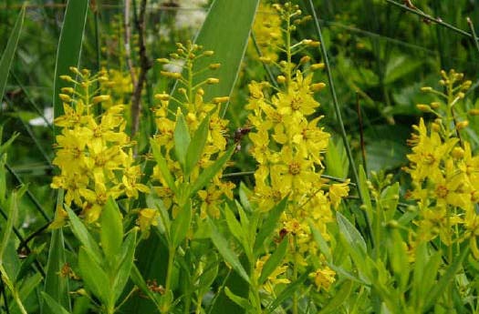
Swamp candle (a.k.a. yellow loosestrife) Lysimachia terrestris in late July. Although "loosestrife" is one of its common names, this native species is not in the same family as purple loosestrife Lythrum salicaria which is an introduced species currently invading North American wetlands.
Source: Zoe Lucas, Green Horse Society
As for fauna found in the Isle Royale National Park, had modern visitors traveled to Isle Royale around 1900, they would not have seen any wolves or moose. Instead, they would have found animals such as a lynx, coyotes, or a herd of caribou, none of which inhabit the island today. Now, the most commonly viewed mammal life in Isle Royale National Park are moose, snowshoe hare, beaver, red fox, and red squirrel, as well as river otter, whose population has increased dramatically in recent years. Sightings of timber wolves remain extremely rare, as they take extreme care to avoid encountering people. Moose immigrated to the island on their own initiative (with theories hypothesizing that they probably swam from Canada's mainland). In 1948-49, during the exceptionally cold winter, an ice bridge formed between Canada and the island, allowing a small pack of Eastern timber wolves to cross over to Isle Royale. This was a fortunate event for the island’s ecosystem, as the wolves keep the moose population in check, because without predators as a control in the past, the moose have overpopulated and destroyed their own food supplies. Bird life on the island is very similar to that of the surrounding mainland, with a wide variety of northern warblers, thrushes, ducks, and raptors.
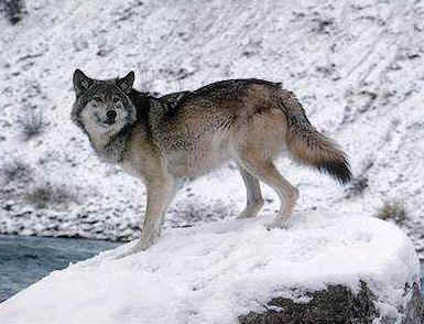
On Isle Royale the most intriguing animal would probably be the gray wolf. It is also commonly called the timber wolf. Isle Royale is one of the few areas that the wolf is being introduced. Although the reintroduction is controversial in some areas of Minnesota and Wyoming, most Michiganders are welcoming the wolves with open arms and eager curiosity. As you can see here, the wolf is roughly the size of a dog, and is a very noble looking animal. Although pictured solitary here, the wolves are usually in packs, in which they hunt, and raise their offspring together.
Here is a video showing a group of four timber wolves attempting to run down an adult moose. Surprisingly (or maybe not to you moose-experts out there), moose can run pretty quickly, so obviously these wolves need some more practice on their hunting techniques.
References
project..isle.royale.national-park.com/
project..nps.gov/isro/
http://coppercountry.com/article_42.php
project..nyx.net/~sjhoward/Isle_Royale/index.shtml
project..encyclopedia.com/html/I/IsleR1oya.asp
Page created by Kevin O'Donnell, a GEO 333 student
This material has been compiled for educational use only, and may not be
reproduced without permission. One copy may be printed for personal use.
Please contact Randall Schaetzl (soils@msu.edu)
for more information or permissions.