This "placemat" map was produced by the Michigan Geographic Alliance and the Science/Mathematics/Technology Center, Central Michigan University, with funding from the U.S. Dept. of Education. For further information email Wayne.E.Kiefer@cmich.edu
THE FLORISTIC TENSION ZONE
You've probably noticed, while driving to northern Michigan, that the vegetation is very
different in the northern lower peninsula and the UP, from that near Lansing. The boundary
between these two floristic zones is called the "floristic tension zone".
In the Lower Peninsula, the floristic tension zone separates two broad regions of
different forest composition. The cause of the abruptness of this line is still being
debated. The gradual increase of northern flora through the Lower Peninsula appears to be
climatically controlled, but the peculiar sharpness of the tension zone may be related to
soils. Coarse, sandy soils are more widespread in the northern portion of the Peninsula,
and their porosity leads to increasing acidity through time. Thus, the soils of the north
are more acidic. The greater prevalence of these sandy soils in northern Michigan permits
the more northern flora to be competitive on a greater number of sites, but south of the
tension zone, the greater prevalence of the heavier glacial till soils, combined with less
favorable climate, restricts these species.
Upland forests south of the tension zone are generally of either oak
and hickory or beech and maple composition. The drier oak-hickory forests are most
commonly found on porous, loose-textured soils (except near Lake Michigan). The dominant
species include black, red, white, and bur oaks, shagbark and pignut hickories, black
cherry, black walnut and red maple. These forests have an open canopy that admits
considerable daylight to the forest floor, even during the summer.
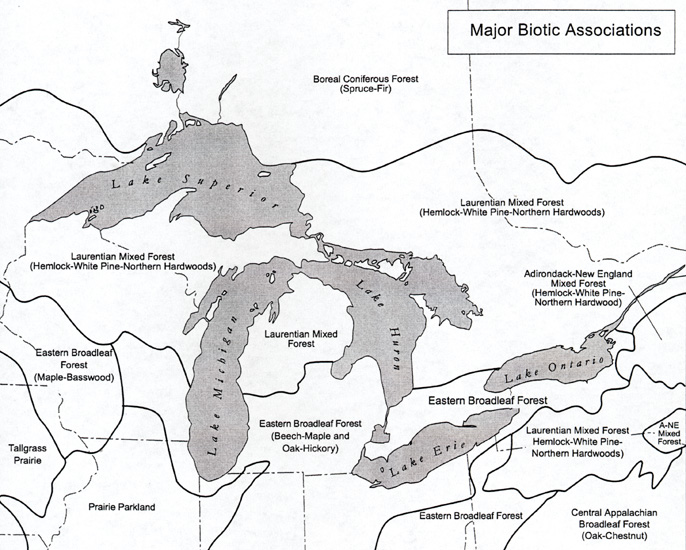
South of the zone, loamy soils and longer growing seasons support
forests that are dominantly broadleaved (deciduous hardwoods). North of this zone, drier,
sandy soils and a climate of long, snowy winters and cool summers support mixed forests.
"Mixed" implies that hardwoods and coniferous softwoods intermingle.
"Softwood" trees are generally synonymous with conifers, or needle-leaf trees.

This "placemat" map was produced by the Michigan Geographic
Alliance and the Science/Mathematics/Technology Center, Central Michigan University, with
funding from the U.S. Dept. of Education. For further information email Wayne.E.Kiefer@cmich.edu
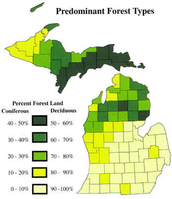
Certain patterns in the present composition of forests in the Lower Peninsula appear to be responses to climatic gradients that extend both south to north and east to west across the state. Moving south to north through the Lower Peninsula, one notices an increase in the number of evergreen (conifer) species. These species (white spruce, balsam fir, jack pine) are boreal in distribution but extend south into northern Michigan on upland sites where they are usually only minor associates of other native hardwoods (though jack pine occurs extensively on sandy uplands). Apparently sensitive to warm, dry summers and neutral or basic soils, and unable to compete with more temperate-climate associates, they are limited primarily to the northern Lower Peninsula--north of a line from Bay City to Muskegon (the tension zone)--and to the Upper Peninsula, where cooler summers and lower evaporation are typical, along with the acidic, sandy soils on which these trees are most competitive. Warmer summer weather with higher evaporation rates seem to restrict their occurrence in southern Michigan.
As the maps below indicate, the exact location of the floristic tension zone is debatable, although it clearly does coincide (in places) with a soils boundary between the sandy soils to the north and more clay-rich loams to the south. Each of the maps below shows the location of the floristic tension zone, as interpreted by one or another scholar.
Source: Image courtesy of Randy Schaetzl, Professor of Geography - Michigan State University
The map below shows where we currently think the tension zone exists. Note that it
continues on into Wisconsin and to the east, into Ontario.

Source: Image courtesy of Randy Schaetzl, Professor of Geography - Michigan State University
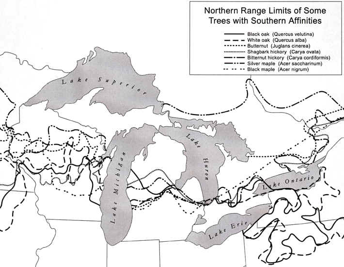
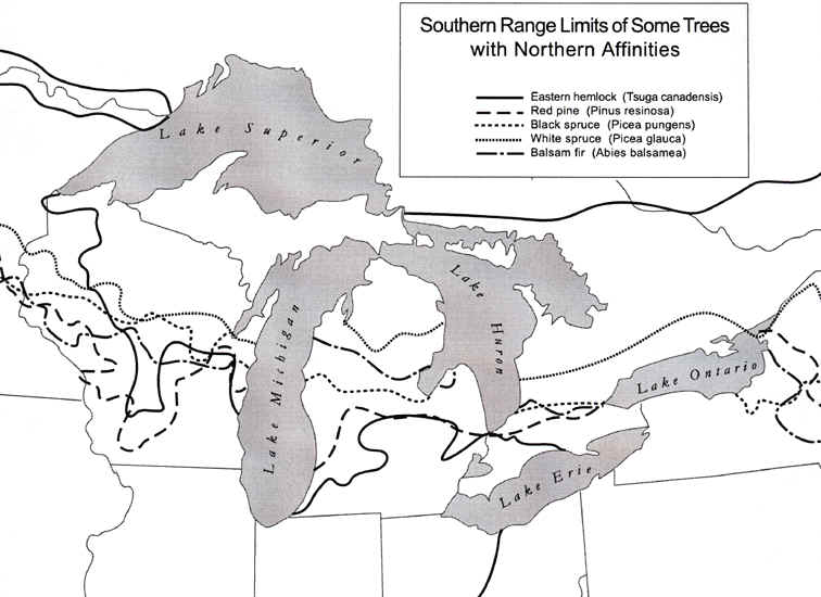
To verify that this tension zone really does exist, the two maps below show the northern
range limits of some trees with southern affinities (i.e., southern trees), and the
southern range limits of more northerly trees. Note how many of the ranges of these
trees end within or near the tension zone.

Source: Image courtesy of Randy Schaetzl, Professor of Geography - Michigan
State University

Source: Image courtesy of Randy Schaetzl, Professor of Geography - Michigan State University
As stated earlier on this page, changes in soil types and texture (loams to the south,
sands to the north) are a major reason for the existence of the tension zone. The
map below, which illustrates soil water holding capacities for the US, clearly shows the
drier soils (yellow) north of the tension zone. It's not so much that the sandy
soils are drier, but rather that they cannot hold as much water as the loamy soils (darker
greens) in the south. Thus, trees that are able to withstand dry periods and compete
well during dry times, like pines, do better in the
north, comparatively so.
Source: Unknown
This material has been compiled for educational use only, and may not be reproduced without permission. One copy may be printed for personal use. Please contact Randall Schaetzl (soils@msu.edu) for more information or permissions.