THE ERIE CANAL
The Erie Canal: Facilitating Travel TO Michigan
Regardless of the prevailing views of Michigan’s land and climate,
a more important factor is delaying any large-scale movement into Michigan in the
immediate postwar years was the difficulty in reaching the territory.
Transportation to Michigan by water was "dangerous, unreliable, and fraught with
discomfort." Navigation on Lake Erie was regarded as more dangerous than on the
Atlantic. Accommodations for passengers were poor. To reach Detroit from the south by land
it was necessary to cross the Black Swamp in northwestern Ohio. In rainy
periods the swamp was virtually impassable. The horrors of the Black Swamp were widely
publicized. At a time when plenty of good land was still available in Ohio, Indiana, and
Illinois, there was little incentive for the pioneer to brave the hazards involved in
getting to Michigan.
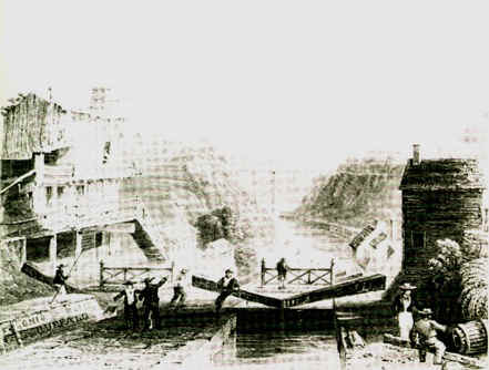
The completion in 1825 of the Erie Canal (below),
connecting Lake Erie with the Hudson River, was an event of major importance in Michigan
history because it greatly facilitated the transportation of passengers and freight
between the eastern seaboard and Michigan ports.
Source:
Unknown
The canal, built by the state of New York at a cost of $7 million, was such a success that
within three years toll charges had paid the cost of construction plus interest charges.
For the first time, New England families, anxious to leave rocky and infertile fields for
richer lands in the West, had a route for reaching the "promised land."
Furthermore, the waterway provided not only an easier way to move to Michigan but access
to markets in the East. Freight rates between Buffalo and New York were reduced from $100
a ton to $25 a ton with the opening of an all-water route between the two cities, and the
rates soon fell even lower.
Important as it was, the Erie Canal did not cause the great migration
to Michigan; it only facilitated that movement. This is shown by the fact that
public land sales at Detroit reached a high point in 1825, the year the Erie Canal opened,
and then declined in the years immediately following. Whereas 92,232 acres had been sold
in 1825, sales were down to 70,441 by 1830.
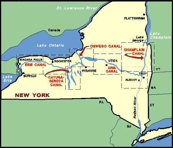
The Erie Canal, in New York state (shown below), was 360 mi (580 km)
long, and connected New York with the Great Lakes via the Hudson River. Locks were
built to overcome the 571-ft (174-m) difference between the level of the river and that of
Lake Erie. It opened in 1825.
Source: Unknown
Source: Unknown
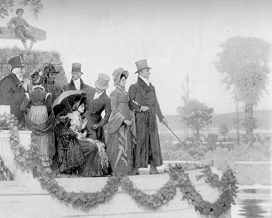
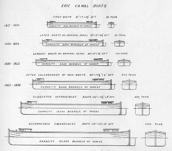
In its early days, the canal was not very large (see below), but it was large enough to
move Michigan's grain and wool east, thereby providing Michigan with a market for it's
commodities, which rapidly fueled the influx of settlers.
Source: Unknown
The boats used on the Canal were generally flat-bottomed, and usually hauled grains, wool, whiskey, and sometimes meat.
Source:
Unknown
Land Transportation
For the improvement of land transportation within the territory, Michigan relied heavily
on the federal government. In 1816 troops of the Detroit garrison began building a road to
the rapids of the Maumee River, near the present city of Toledo. By 1819 it was "cut
through" and bridges over rivers and marshes had been built, but the road was still
poorly located and almost impassable for wagons. A road across the Black Swamp from the
settled part of Ohio to the Maumee Rapids was completed the same year. Thus, by 1827 land
transportation to Detroit from the south had been greatly improved.
Roads from Detroit into the interior were required, however, before any
large-scale settlement of Michigan territory was possible. In 1816 the territorial
government launched a project to build a road northward from Detroit, but the road was
inadequate and by 1822 had reached only as far as Pontiac. A post road from Pontiac
through Flint to Saginaw was laid out in 1823. Intervening swamps made progress difficult.
The first road westward also was a military road, designed to connect
Detroit with Fort Dearborn. It followed the path of the Old Sauk Trail and is the
approximate route of the present US 12. It ran westward from Detroit to Ypsilanti, then
veered to the southwest, and continued through the southernmost tier of Michigan counties.
The eastern portions of this road were in use by the latter 1820s, and by 1835 two
stagecoaches a week operated between Detroit and Fort Dearborn. This highway, known then
as the Chicago Road, became "practically an extension of the Erie Canal and...a great
axis of settlement in southern Michigan". Another road westward was known as the
Grand River Road. It generally followed the route of the present I-96 freeway, and in
places is still known as "Grand River Avenue". It followed an old Indian
trail.
These roads were a far cry from their modern counterparts. It can
hardly be said that they were "built" at all, as we think of highway building
today. Surveyors selected the route, often following Indian trails, axemen cut away the
brush and felled trees low enough along the path so wagons could pass over the stumps, and
workman constructed crude bridges over streams which could not easily be forded. Logs were
laid across the road over bogs and swamps to prevent wagons and animals from miring. This
was known as a "corduroy road". Other than this, little was done to provide a
surface for the roads. They were notoriously bad.
Settlers along the roads took a proprietary interest in the mudholes,
and the right to pull wagons out of one of them for a price was recognized as belonging to
the man who lived nearest to it. It was said that these mudholes were fostered
carefully in dry weather; one tavern keeper found a buyer for his property partly, it was
said, because he had nearby an especially profitable mudhole.
Since the roads were laid out to follow the routes having the fewest
obstacles, they were seldom straight. A description of the Chicago Road stated that it
"stretches itself by devious and irregular windings east and west like a huge serpent
lazily pursuing its onward course utterly unconcerned as to its destination.
Bad as they were, these roads were of utmost importance in the early
settlement of Michigan. Trails branched off along the routes followed by the major roads,
which served to guide the traveler to a destination beyond the main roads. Along the chief
roads taverns were built and towns sprang up.
Finally, by the end of the 1820's, with the relinquishment of Indian
claims to the lands in southern Michigan, the rapid progress of the surveys, the opening
of land offices, and the improvement of transportation facilities, the way had been
prepared for what shortly developed into one of the great land booms in all of American
history as settlers poured into and across the lower third of Michigan’s southern
peninsula.
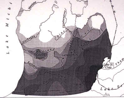
The map below shows the tremendous influx of settlers to the state during the early
1800's, especially in the 1830's.

Source:
Unknown
And below is a close-up of that map for the southernmost part of Michigan.
Source:
Unknown
The majority of the newcomers came by way of the Great Lakes, making the journey from
Buffalo to Michigan by steamship or sailing vessel. Detroit was the major point of entry.
Some settlers landed at Monroe and a few at smaller ports on the east, while some, seeking
land in western Michigan, went by lake vessel around the Lower Peninsula, landed at St.
Joseph or other ports on Lake Michigan, and proceeded from there into the interior.
Sizable numbers came northward overland from Ohio and Indiana into the southern counties
of Michigan. Some used the "Michigan Road," which the federal government built
between Madison, Ohio, and the foot of Lake Michigan.
Below is an excerpt I found on the web. It's an e-conversation between two people.
I found it interesting:
Q: I am interested in any information anyone might have
one how the ancestors got from WESTERN NEW YORK to MICHIGAN in the mid 1800's. I have
heard that some came over the lakes once they froze over. Many of our ancestors roots are
originally in New York, how did they get here??
A: One relation of ancestors that I have been able to track found
their way to Hubbardston, Ionia County. Angeline and her husband arrived in Hubbardston,
Michigan in 1854. They came by way of the Erie Canal to Buffalo, NY, and then sailed on a
ship to Detroit. From Detroit, they took the railroad to Owosso, Michigan, where the
railroad ended. From there they caught the work train from Owosso to Saint Johns and then
traveled by oxcart to Plains. They stopped at a friend's house in Matherton for two weeks
before going on to Hubbardston. They lived there for two years fighting malaria. Then they
bought and cleared land in Bloomer Township, in Montcalm County two miles away form the
then-non-existent Carson City, where Angeline pulled her end of a crosscut saw and had to
contend with Indians who were numerous.
Some of the text on this page was adapted from Dunbar and May's Michigan A History of the Wolverine State.
This material has been compiled for educational use only, and may not be reproduced without permission. One copy may be printed for personal use. Please contact Randall Schaetzl (soils@msu.edu) for more information or permissions.