This page was created to assist students who are beginning to learn the "ins and outs" of the US Public Land Survey system. Although it lies within the GEO 333 web page milleau, I hope it is useful to students in many other courses.
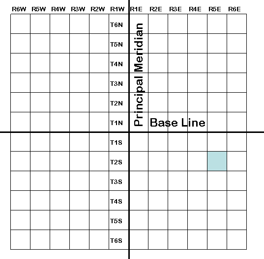
The USPLS is a rectangular survey system that was set up by the Land Ordinance of 1785. This system cuts the land into rectangles so it all could be sold by the federal government. This system uses a Principal Meridian, a Base Line, and an initial point as its standard. The initial point is where the Principal Meridian and the Base Line cross. A grid of lines, parallel to the Principal Meridian and the Base Line, is laid down cutting the land into townships. Each township is six miles by six miles. Townships are described by how far north/south and east/west they are of the initial point.
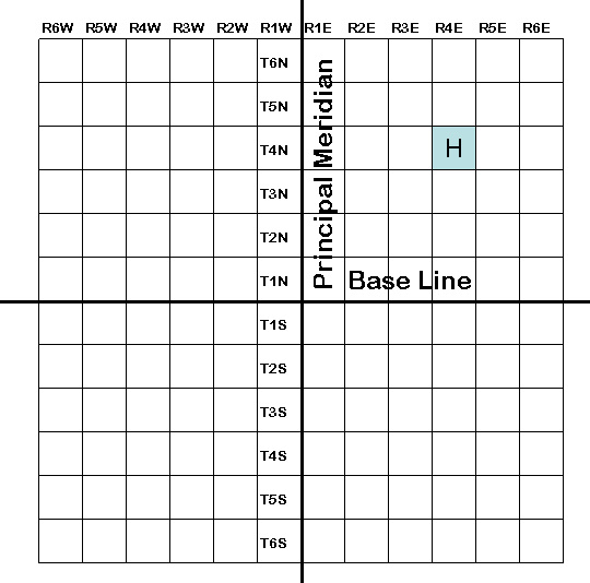
The township labeled H below would be described as
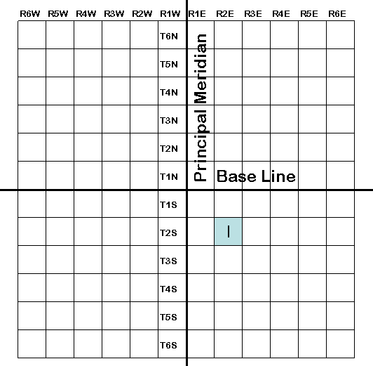
T4N, R4E (Township 4 North, Range 4 East). T2S, R2E (Township 2 South, Range 2 East)
Township subdivision designations.
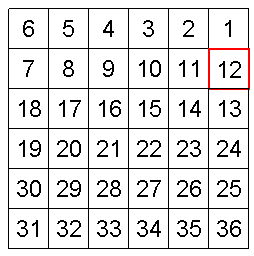
Each six mile by six mile township is broken into 36 equal parcels of land called sections.
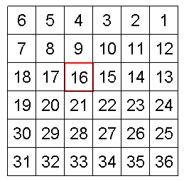 As shown in the above enlargement of
T2S, R2E, sections are made by using lines parallel to the outside of the
township.
As shown in the above enlargement of
T2S, R2E, sections are made by using lines parallel to the outside of the
township.
All sections are one square mile and are equal to 640 acres.
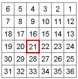
They are numbered starting in the northeastern corner with section one.
The numbers wind back and fourth until they get to number 36 in the southeast corner.
To describe a plot of land down to a section all that needs to be done is that the "section" and the section number needs to be added to the description of the township. So the description of section one in this township would look like this, Section 16, T2S, R2E.
Section designations:
Since few people own an entire section (640 acres) of land, the USPLS system provides for additional subdivision of the section into smaller parcels of land. Below are two separate blow-ups of section 21.
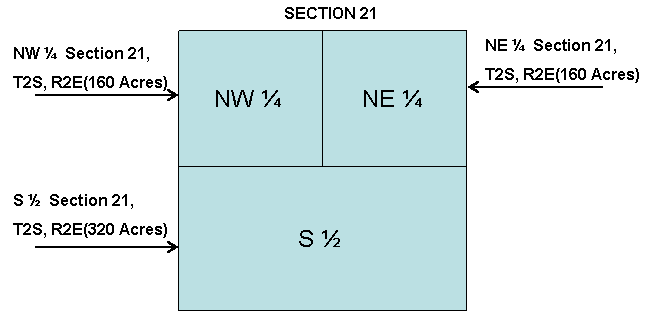
The one on the above is cut into halves and the top half is cut in half again to make two quarter sections and one half section. A half section is 320 acres and a quarter section is 160 acres.
The one below is broken up into much smaller parcels. Parcel L is a half of a quarter section and M is a quarter, quarter section. L is an 80 acre land plot and M is 40 acres. N is a half of a quarter, quarter section and P is a quarter, quarter, quarter section. N is a 20 acre piece of land and P is a 10 acre section. P is the smallest break down of land in the USPLS. The USPLS descriptions of these partial sections is below.
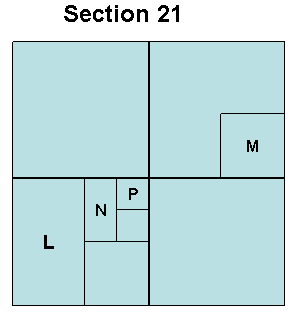
L) W1/2, SW1/4, Section 21, T2S, R2E
M) SE1/4, NE1/4, Section 21, T2S, R2E
N) W1/2, NE1/4, SW1/4, Section 21, T2S, R2E
P) NE1/4, NE1/4, SW1/4, Section 21, T2S, R2E
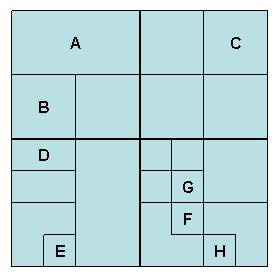
Now try to describe the remaining lettered areas by yourself.
T2S, R2W, Section 21
Answers below (scroll down).
Answers:
A) N1/2, NW1/4, Section 21, T2S, R2W
B) SW
1/4, NW1/4, Section 21, T2S, R2WC) NE
1/4, NE1/4, Section 21, T2S, R2WD) N
1/2, NW1/4, SW1/4, Section 21, T2S, R2WE) SE
1/4, SW1/4, SW1/4, Section 21, T2S, R2WF) NE
1/4, SW1/4, SE1/4, Section 21, T2S, R2WG) SE
1/4, NW1/4, SE1/4, Section 21, T2S, R2WH) SW
1/4, SE1/4, SE1/4, Section 21, T2S, R2WNow let's work on acreage of parcels. A full section is 640 acres, which means a quarter section is 160 acres, etc.
Try to describe these partial sections and include the acreage. Answers are listed below; scroll down.
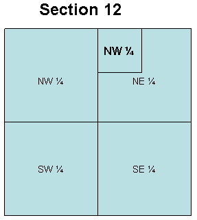
EXAMPLE: B) NW1/4, NE1/4, SECTION 12, T2S, R5E 40 ACRES
Here are a few more examples (Scroll down for the Answers)
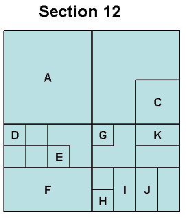
Answers to partial sections with acreage
A) NW1/4, SECTION 12, T2S, R5E 160 ACRES
C) SE1/4, NE1/4, SECTION 12, T2S, R5E 40 ACRES
D) NW1/4, NW1/4, SW1/4, SECTION 12, T2S, R5E 10 ACRES
E) SW1/4, NE1/4, SW1/4, SECTION 12, T2S, R5E 10 ACRES
F) S1/2, SW1/4, SECTION 12, T2S, R5E 80 ACRES
G) NW1/4, NW1/4, SE1/4, SECTION 12, T2S, R5E 10 ACRES
H) SW1/4, SW1/4, SE1/4, SECTION 12, T2S, R5E 10 ACRES
I) E1/2, SW1/4, SE1/4, SECTION 12, T2S, R5E 20 ACRES
J) W1/2, SE1/4, SE1/4, SECTION 12, T2S, R5E 20 ACRES
K) N1/2, NE1/4, SE1/4, SECTION 12, T2S, R5E 20 ACRES
L) SE1/4, NE1/4, SE1/4, SECTION 12, T2S, R5E 10 ACRES
Finally, many thanks to Jeff Kutschman, who compiled this page for GEO 333.
This material has been compiled for educational use only,
and may not be reproduced without permission. One copy may be printed for
personal use. Please contact Randall Schaetzl (soils@msu.edu)
for more information or permissions.