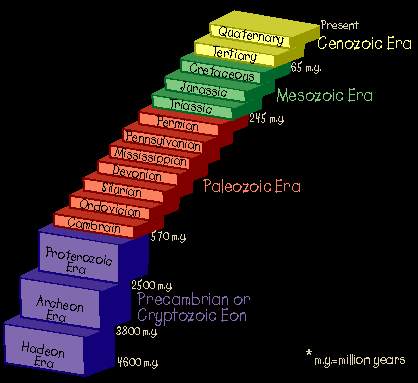
THE PRECAMBRIAN ERA
The Precambrian Era. The name means: "before the Cambrian period." This old, but
still common term was originally used to refer to the whole period of earth's history
before the formation of the oldest rocks with recognizable fossils in them. In the last
few decades, however, geologists have found that there are some hard-to-discern fossils in
some Precambrian rocks, so this period is now also known as the Cryptozoic or
"obscure life" Eon (from the words "crypt" = "hidden," and
"zoon" = "life").
The Precambrian covers almost 90% of the entire history of the Earth.
It has been divided into three eras: the Hadean, the Archean and the Proterozoic.
Source: Unknown
The Precambrian Era comprises all of geologic time prior to 600 million
years ago. The Precambrian was originally defined as the era that predated the
emergence of life in the Cambrian Period. It is now known, however, that life on Earth
began by the early Archean and that fossilized organisms became more and more abundant
throughout Precambrian time.
The two major subdivisions of the last part of the Precambrian are the
Archean (oldest) and the Proterozoic. Rocks younger than 600 Ma are considered part
of the Phanerozoic.
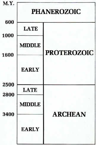
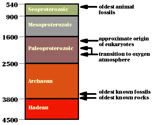
Below is another type of breakdown of Precambrian time.
Source: Unknown
Hadean
Hadean ("Hades-like") Era. This era began with the formation of the earth from
dust and gas orbiting the Sun about 4.6 billion years ago. During this era the surface of
the Earth was like popular visions about Hades: oceans of liquid rock, boiling sulfur, and
impact craters everywhere! Volcanoes blast off all over the place, and the rain of rocks
and asteroids from space never ends. It's hard to take a step without falling in a pool of
lava or getting hit by a meteor! The air is hot, thick, steamy, and full of dust and crud.
But you can't breathe it anyway: it's made of nothing but carbon dioxide and water vapor,
with traces of nitrogen and smelly sulfur compounds! Any rocks that do form from cooling
lavas are quickly buried under new lava flows or blasted to bits by yet another impact.
Some people think that an asteroid as large as the planet Mars hit the Earth near the
beginning of the Hadean era, completely smashing and melting the Earth and forming the
Moon as part of the "splash!" Wow! No one has found any rocks on
earth from this era. Only meteorites from space and moon rocks are this old. If any
life formed on earth during this era, it was probably destroyed.
HADEAN EARTH
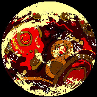
Source:
Unknown
Archean
Archean ("Ancient" or "Primitive") Era. This era begins about a
billion years after the formation of the earth, and things have changed a lot! Mostly
everything has cooled down. Most of the water vapor that was in the air has cooled and
condensed to form a global ocean. Even most of the carbon dioxide is gone, having been
chemically changed into limestone and deposited at the bottom of the ocean. The air is now
mostly nitrogen, and the sky is filled with normal clouds and rain. The lava is also
mostly cooled to form the ocean floor. The interior of the earth is still quite hot and
active, as shown by the many erupting volcanoes. The volcanoes form lots of small islands
in long chains. The islands are the only land surface. The continents have not formed yet.
The islands are carried over the surface of the earth by the movement of rock deep in the
earth's interior. (This movement results from the loss of heat from the deep interior and
is called plate tectonics.) Occasionally the small islands collide with each
other to form larger islands. Eventually these larger islands will collide to form the
cores of the continents we know today. Thank goodness those pesky asteroids and
meteorites are now mostly gone, so impact craters form only occasionally. What about life?
If you look closely, you will see evidence of blue-green algae (actually simple bacteria)
floating in the ocean. That's all there is! Just single-celled bacteria in the ocean.
There is as yet no life on land. Life began in the ocean near the beginning of this era.
The oldest known fossils - the remains of different types of bacteria - are in archean
rocks about 3.5 billion years old.
ARCHEAN EARTH
Source:
Unknown
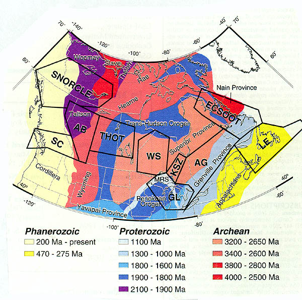
The maps below show the probable locations of Archean (early Precambrian) rocks, which in
many cases formed the early continental cratons. Cratons are large areas of continental
lithosphere (or crust) that have remained coherent and relatively rigid since the
Precambrian. Laurentia, the North American craton, is one of the oldest and largest. It
includes the Precambrian shields of Canada and Greenland, the covered platform and basins
of the North American interior. Laurentia owes its existence to a network of Early
Proterozoic orogenic belts. Many of the belts are collision zones preserving only the
deformed margins of formerly independent microcontinents composed of Archean crust. Other
belts contain accreted Early Proterozoic island arcs and associated intraoceanic deposits.
Thus, we now know that cratons were the early "cores" of the
continents; sedimentary rocks accreted onto the edges of these cratons later in geologic
time, and then were folded and bent up into mountains as one craton collided with another,
or were down-dropped when the cratons split (rifted) apart. Note that the craton for North
America, now called the Canadian Shield or the Laurentian Shield, is located just to the
north of Michigan, and includes parts of the western UP.
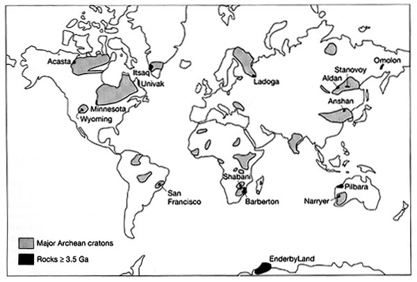
Source: Unknown
The early, Precambrian continents were unlike those we know today: they were smaller and
had surfaces of igneous rocks. No life lived upon them. Continued squeeze of the cooling,
shrinking crust caused the pent up forces beneath to revolt many times and push the land
masses higher, or crack their edges and there pour forth molten rock in quiet or explosive
volcanic activity. High mountain ranges and plateaus were built or pushed up above the
level of the ocean until finally the continents settled to the forms of continental blocks
our geographies show today.
However, the Precambrian oceans did not settle in the basins we know,
but covered much of the continents with shallow seas in which the story of a billion years
of earth history was to be recorded. The continental shelves are, even today, covered by
shallow seas and there the geologic history of today is being recorded. What are these
records made in the shallow seas--- these tablets of time on which the story of ages is
told? When the first igneous rock cracked, when the first drop of water moved, the record
began. When the atmosphere cooled and frost arrived the recording became more rapid. When
plant and animal life became abundant the record became complicated. Changes of
temperature caused the granitic rocks to flake off at the surface, gravity and moving
waters carried the loosened rocks down the slopes, rolled them together, broke them into
smaller and smaller particles, carried them to the sea where they became sediments that
muddied the seawater. Some of the sediments were dissolved in the water, and as the
process kept on through the ages the seas became salty. The sediments, sorted by waves and
currents of the first oceans, settled to the bottom of the seas and were spread out on the
sea floor. In the course of a long time, as layer upon layer of sediments were piled one
on another, they were compressed, cemented, and consolidated into rock which we call
sedimentary. Each layer or bed is a stratum; layered or bedded rock is said to be
stratified.
Various minerals in the ancient igneous rocks were made over into
different sediments. The hard minerals like quartz collected together as sand, and being
heavy, were not carried so far out to sea. They built up coarse and fine rocks which we
call sandstones. Other minerals were broken up into fine clay and silt muds that were
carried far from shore but eventually settled on the sea floor and compacted to a rock we
call shale. Some of the minerals disintegrated to form lime, or calcium carbonate. As the
igneous rocks were eroded some minerals dissolved and were carried to the sea in solution;
there certain chemical reactions caused the lime to be precipitated and in places to build
up great thicknesses of lime mud that eventually solidified into a rock known as
limestone. Other chemical reactions caused iron minerals to be formed which in turn
settled to the bottom of shallow seas, and later in the geological history gypsum and salt
crystallized out of the sea water to form great beds of gypsum and rock salt.
Source: Unknown
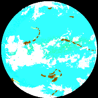
Proterozoic
Proterozoic ("Early Life") Era. Well, here we are about 700 million years ago,
near the end of the longest time period in geologic history. It began about two billion
years after the formation of the earth and lasted about another two billion years! So what
has happened in all that time? Hmmmmm. There is a lot more land to be seen. In fact,
there are two supercontinents, one visible across the equator on this side of the earth
and another one on the other side. These huge masses of land formed by collisions of the
many, many islands made by volcanoes during the Archean and most of the Proterozoic eras.
The earth's interior has cooled some more, and there are fewer volcanoes than in the
Archean. Even though the movements of the earth's surface we call Plate Tectonics are
still very fast and continental collisions are frequent (every few hundred million years
or so!), the centers or cores of the continents are now quite large and stable. In fact,
geologists date the beginning of the Proterozoic Era by the age of the oldest continental
rocks that have not been reheated or chemically altered. Life has not changed much during
the last two billion years, but the few changes are significant. Life is still found only
in the ocean, but somewhere around 1.7 billion years ago, single-celled creatures appeared
that had a real nucleus. Another important change is about to happen: true multi-celled
life is about to appear, some 30 million years before the end of the Proterozoic. These
multi-celled creatures will have no hard parts like shells or teeth in their bodies, so
their fossils will be hard to find. The atmosphere is about the same, mostly nitrogen,
with a little water vapor and carbon dioxide. But what's this? Free oxygen released by the
algae floating in the oceans is beginning to collect in the air. These single-celled
plants have been producing oxygen for about two billion years, but up until now the oxygen
has been combining chemically with iron and other elements to form great mineral deposits
around the world. Paradoxically, this oxygen, which we must have to live, is poisonous to
most of the life forms living on the Earth during the Proterozoic, so another great change
in the types of life is about to occur.
The earth at this time is also very cold, with huge, bluish glacial ice
sheets visible across the supercontinent, even in the normally warm equatorial regions!
In fact, glaciers invaded Michigan at this time; this glaciation is referred to as
the Gowganda glaciation.
PROTEROZOIC EARTH
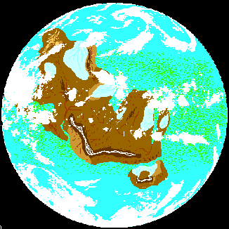
Source: Unknown
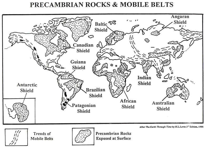
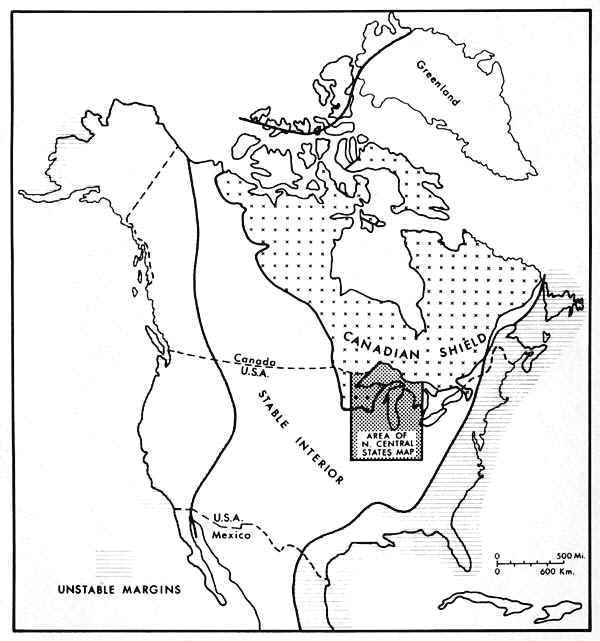
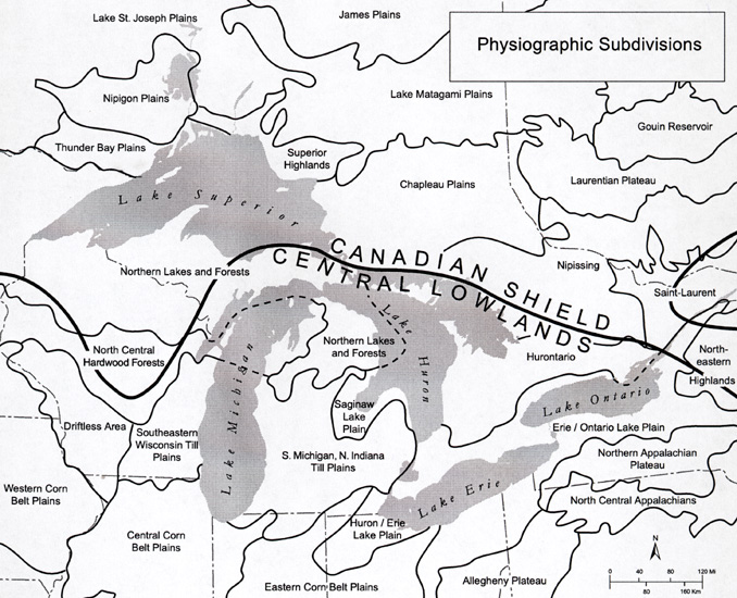
Now let's focus in on the one craton that affects Michigan: the Canadian Shield.
Michigan began when a shield-shaped mass of igneous rock, nearly two million square
miles in area and centering about Hudson’s Bay, formed the original continent of
North America which we refer to as the "Canadian Shield." The point of the
shield extended southward across the area now the western half of the Northern Peninsula
into Wisconsin, and its southern edge was a northward-bearing arc extending from the Lake
Superior region to the Adirondacks. Southward was a shallow sea covering the remainder of
the continental block. The granite floor of the sea had many depressions and ridges, but
only the basin-shaped depression bordering the shield on the southeast need interest us.
The basin shallowed scoop-fashion eastward, but the deepest part was about where the
Southern Peninsula is now. That was the early setting of Michigan, the basal foundation of
the State.
The maps below show the extent of the Canadian Shield. To its east lies
its unstable edge, where folding of the rocks would later cause the Appalachians to form.
To its west and south, more stable parts of the continents existed, where only subtle
down-warping and up-warping occurred. One of these "downwarped" areas would
later become the Michigan basin, in which many thousands of meters of sediments
accumulated and later became rock.
Source: Unknown
During the first part of the Proterozoic, a 200 million year-period of quiet, which we
name the Huronian from its record north of Lake Huron, thick sediments were laid
down in a shallow sea trough that covered the Lake Superior region. In places thick sand
was deposited; in other fine muds, and in other places pure lime, accumulated in the
shallow but slowly deepening sea. Over the sand great masses of iron minerals accumulated,
either by chemical action or by the work of iron forming bacteria, or by both and perhaps
other means, until vast thicknesses of sand and iron sediments were built up, and the
world’s largest iron deposit was in the making in Minnesota, Wisconsin, and Michigan;
and in that far ago time the foundations of Michigan’s wealth and the automobile
industry were laid in the old Huronian sediments we now find in the iron ranges of
Marquette, Baraga, Iron, Dickinson, Menominee, and Gogebic counties.
Source: Photograph by Randy Schaetzl, Professor of Geography - Michigan State University
The map below shows in detail where the important boundary is between the Precambrian
rocks (PC: of the Canadian Shield) and the Paleozoic-age sedimentary rocks of the Michigan
Basin and surrounding areas (C: for Cambrian).
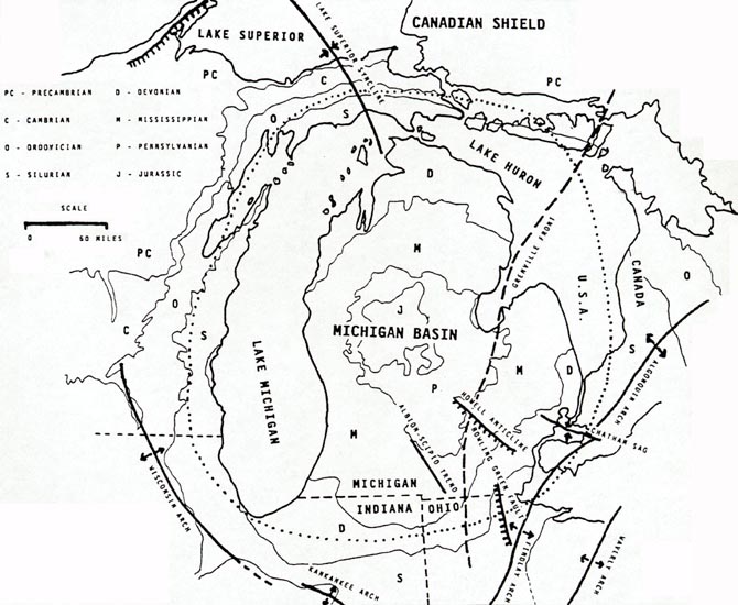
Source:
Unknown
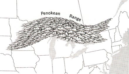
As soon as water fell on the Canadian Shield and the first winds blew, rock weathering
began. The rocks started to flake off and break up, and erosion was initiated. Sediments
were carried to and deposited in the seas, and the first sandy beaches were formed.
Several times in these early turbulent eons the land at the edges of the seas were lifted
into high mountain ranges, like the Penokeean Range, only to be worn down and
their sediments carried to the seas to build up new shores and to be spread on the sea
floor to form stratified masses of sandstones, shales, and limestones. Each newly formed
beach increased the land area and advanced the land-water boundary southward. With each
successive uplift the sedimentary rocks were bent, folded, broken, twisted, contorted, and
changed. Masses of hot igneous rock were forced into the broken formations, completely
changing or metamorphosing them in many places so that the rocks made in the several
periods of mountain building and sedimentation became a very complex mass of disturbed,
broken (faulted), distorted rock --- the oldest rocks that underlie the western half of
the Northern Peninsula. All we can see of the oldest rocks are the Huron Mountains and the
other granites and their kindred of Marquette, Baraga, and Gogebic counties. Once they
were a mountainous seacoast, but their summits were worn in turn and all but the highest
buried under later sediments.
Source: Unknown
Rumblings of a new geologic disturbance, mountain building, interrupted the quiet Huronian
sedimentation of the Early Proterozoic, 2.5 - 1.6 billion years ago. Again mountain
building, termed the Penokean Orogeny (1.8 billion years ago) lifted the sediments, now
hardened to rocks, to mountain heights, and in so doing crumbled, folded, and contorted
them. The sandstones were metamorphosed to quartzite, shales to slate, limestones to green
and white marbles, and the iron sediments were folded and changed with them. The rocks
were cracked and broken; they slipped and moved along faults, vertically and horizontally.
Some rock blocks were shoved up onto others, some were tipped on end until a madly jumbled
mass was made of the flat Huronian sediments. The red and black jaspillite of Jasper Knob
near Ishpeming shows what happened. Into cracks in the rock warm and hot waters, heavily
mineral-laden, made their way. These waters left deposits of minerals that are the joy of
the collector, although the complex Huronian rocks in which they are found have been the
lure, despair, and subject of great dispute among geologists for the last hundred years.
The pink pegmatite dike in the glistening white marble of Felch Quarry tells a tale of
long sedimentation of pure lime metamorphosed to marble, perhaps by the very molten rock
that cracked and forced its way through the marble, then slowly cooled, forming large
crystals of pegmatite.
Parts of the text above have been paraphrased from C.M. Davis’ Readings in the Geography of Michigan (1964).
This material has been compiled for educational use only, and may not be reproduced without permission. One copy may be printed for personal use. Please contact Randall Schaetzl (soils@msu.edu) for more information or permissions.