Less than 90 years ago Michigan had no refineries and no oil wells. With the breakup of the Old Standard Oil company into separate companies in 1911, the petroleum industry entered into an era of stiff competition--an era which is producing the technological progress necessary to match automotive improvements. Small "shows" (a "show" is a successful well) of oil had been reported in Michigan before the turn of the century, but it was not until 1925 that the Saginaw Prospecting Company, headed by James C. Graves, brought in the state’s first commercial well in Saginaw County. In the 30 years which followed, Michigan’s relatively shallow fields have produced 385 million barrels of crude oil and 300 billion cubic feet of natural gas.
Michigan’s oil and gas industry began in 1925 when oil in commercial quantities was drilled near Saginaw. Since then, more than a billion barrels of oil and 3 trillion cubic feet of gas have been produced in the state--all in the lower peninsula (see below).
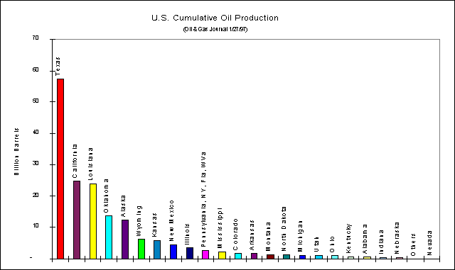
Cumulative Oil Production (barrels): 1859-1996
Texas 57,208,460,000
California 24,815,513,000
Louisiana 23,991,782,000
Oklahoma 13,918,796,000
Alaska 12,613,190,000
Wyoming 6,396,614,000
Kansas 5,999,153,000
New Mexico 4,680,086,000
Illinois 3,506,016,000
Pennsylvania, NY, Fla, and WVa 2,713,818,000
Mississippi 2,149,284,000
Colorado 1,768,855,000
Arkansas 1,710,119,000
Montana 1,419,958,000
North Dakota 1,235,344,000
Michigan 1,194,116,000
Total U.S.A 169,972,290,000
In 1970, hydrocarbon (oil and gas) production in Michigan took a giant
leap forward with the discovery of the Niagara Trend. In the 1980's a similar discovery
occurred when natural gas was hit in deeper strata known as the Prairie du Chien
formation, and in the Antrim shale. These last two discoveries took Michigan’s gas
production from 40 billion cu feet per year (1975) to 170 billion cu feet in 1990. In
1990, Michigan was the 16th largest oil producer and 13th largest gas producer in the US
in 1994, and tops among midwestern states.
Petroleum and natural gas are trapped in various ways in
sedimentary rock layers. The 14,000 ft of sedimentary rocks found on top of the
Precambrian rocks in Michigan represent great potential for the accumulation of oil and
gas. However, rocks that produce much of the petroleum and natural gas in other parts of
the United States and the world---of the Mesozoic and Cenozoic eras---are largely absent
from the Michigan geologic column. Thus, liquid fossil fuels in Michigan must come
dominantly from the sandstones, limestones, and shales of the Paleozoic era.
Oil and gas originate when organic materials, trapped in ocean-bottom
sediments, decompose within the rocks and form oozes and liquids known as hydrocarbons.
Hydrocarbons then migrate along and within permeable rock layers until they get to an area
that is impermeable--areas called "traps".
One of the major oil and gas "traps" in southern Michigan is
the Albion-Scippio Trend, in Jackson and Calhoun Counties (see map below). Other
important structural traps include the Howell anticline and the Sanilac Fault.
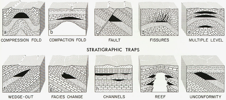
The diagram below shows the many different ways that such traps can originate. Most
of the hydrocarbon traps in Michigan are associated not with faults but with the edges of pinnacle reefs.
Source: Unknown
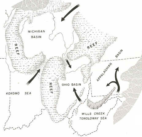
At the edges of the Michigan Basin, many pinnacle reefs grew, formed and became buried.
Today they are our major oil and gas production areas. In
1979, 55 of the 83 counties in Michigan were producers for petroleum---all of them were in
the Lower Peninsula. In fact, only 13 counties in the Lower Peninsula produced no oil, and
six counties produced over 1 million barrels. All of these six counties lie within the
Niagaran-Silurian Reef system, which has been exploited since the late 1960s because
improved technology and higher prices made greater profits possible, despite the
considerable risk involved. Five of the six counties are in the northern Niagaran Reefs
area---currently the most active oil and gas region in Michigan---where production began
in 1969. Considerable amounts of oil and gas were sealed in the Niagaran Reefs, which
formed along the edges of a salt sea that covered Michigan during the Silurian period. The
pinnacle reefs were coral formations that long ago changed into porous, carbonate rock.
They are isolated from one another and average from 100 to 200 acres in size: thus the
search for them has resulted in a number of dry holes. The success rate has improved in
recent years with better exploration and seismic testing methods. Improved pipe technology
in the holes has also contributed to the increased success rate.
The annual oil production in Michigan has varied considerably since
exploration began in 1920, and which formations have contributed to the total has varied
as well---in 1979, the Silurian-Niagaran Reef accounted for 29 million barrels of the 35
million barrels produced. Gas production trends show similar fluctuations in the total
produced and from which formations.
Michigan’s production of both represents only a small percentage
of the state’s oil and gas needs, but there is considerable potential for further
production in existing and new fields. Oil is known to lie under extensive areas of Lake
Michigan, but there is little likelihood of drilling in the lake in the near future.
Source: Unknown
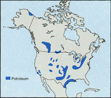
In part because of our reefs, Michigan has significant deposits of oil and natural gas, as the regional map below shows (in blue), and the detailed state map below it also shows where oil and gas are found.
Source: Unknown
The map below shows the locations of the all oil and gas wells in the
state. There are no such wells in the UP. Antrim gas comes from
shallow shale beds. The bituminous and combustible nature of the Antrim shale beds has
been known for a long time but production has not been active until about 1950.
Antrim shale outcrops, show below, are NOT drilled. Rather, the shale is drilled for
gas at places where it is shallowly buried. Where it is the outcropping rock, all
the gas has leaked out!
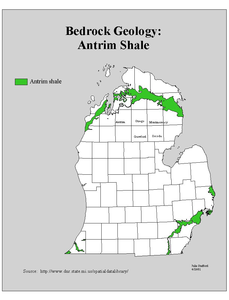
The map above shows where the Antrim crops out at the surface. But the gas wells
into the Antrim shale, shown in the map below as red dots, occur in areas slightly to the
south, where the Antrim shale is slightly buried. Here's the story: Beginning in the
1980's, natural gas was found in the Antrim shale in greater quantities than expected,
which (coupled with tax breaks offered to drillers) prompted a drilling frenzy. Antrim gas
drilling is almost a sure thing--it has a better than 90% success rate. Most of the Antrim
gas is extracted in Antrim, Crawford, Montmorency, Oscoda and Otsego Counties. After a
well is drilled, a six month dewatering period takes place. After that time the well
begins to stabilize. The water (brine) is pumped back into the rock via a nearby well. The
more water (brine) brought up, the more productive the well will be, because it means that
more gas will eventually be released from the fractures in the shale. Brine is salty
water, and is a potential contaminant. The Antrim shale gas wells are shown
as the large red swath across the northern lower peninsula.
COLOR KEY: oil wells gas
wells dry holes
Source: State of Michigan DNR
The map above shows where drilling activity is taking place, while the map below gives
names to some of the major oil and gas fields (this map is too old to show the Antrim gas
field in the extreme northern lower peninsula).
Source: State of Michigan DNR
Note the large concentration of wells in the northwestern lower peninsula, in Antrim,
Kalkaska, Otsego and Crawford Counties.
Source: Unknown
Note that Michigan is a relatively small "player" in US oil and gas production
(as of 1997), but that, nonetheless, we do produce more oil and gas than most other
states.
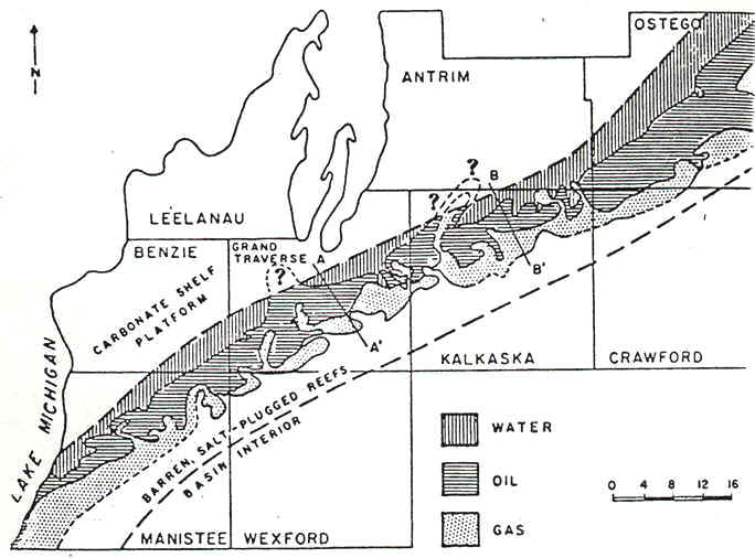
This is an area of extensive reef development, as the map below shows, and hence the major
oil and gas finds in this area. On the basin-ward side of these reefs gas deposits
are located, while oil is located on the reef proper.
Source: Unknown
Click here to go to part II of this page.
Some of the images and text on this page were taken from various issues of Michigan History magazine and have
been paraphrased from C.M. Davis’ Readings in the Geography of
Michigan (1964).
This material has been compiled for educational use only, and may not be reproduced without permission. One copy may be printed for personal use. Please contact Randall Schaetzl (soils@msu.edu) for more information or permissions.